1900s (20th Century) Maps of Mullins, South Carolina
Explore 7 historic maps of Mullins from the 1900s (20th Century). These maps offer a rare glimpse into what life looked like during the 1900s — showing old roads, neighborhoods, homes, and landmarks that have changed or disappeared over time.
Whether you're researching your family's past, planning a metal detecting trip, or studying how Mullins's landscape evolved across the 1900s, these high-resolution maps are a powerful tool for exploring the history of this region.
- Focus on a specific era: All maps on this page are from the 1900s, giving you a focused view of this time period.
- See what’s changed: Compare century-old streets, trails, and buildings to today's modern landscape using overlays and satellite layers.
- Research with precision: Use these maps for genealogy, historical research, land use analysis, or educational projects.
- View, download, or print: Maps are fully viewable online in high resolution, and can be downloaded or printed for your own records.
Start exploring Mullins's history through authentic maps from the 1900s. This is your window into the past.
Mullins, SC maps
(7)- 1946 Map of Mullins, 1956 Print
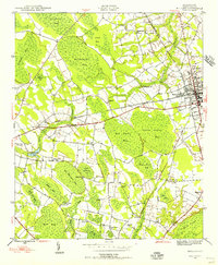 1946 Mullins1956 Print · USGSMarion County was an active railroad and agricultural hub in the mid-1940s, centered on the junction of two major rail lines. Genealogists can trace rural family roots through landmarks like Livingston Cem, Gapway Sch, and Little Bethel Ch.4 unique versions available
 - 1947 Map of Mullins
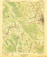 1947 Mullins1947 Print · USGSMarion County at the close of the 1940s is a landscape of intersecting railroads and unique Carolina Bays. Researchers can trace rural life through sites like Smith Swamp Sch, Wise Chapel, and numerous family burials including Ammons Cem.2 unique versions available
 - 1948 Map of Nichols, 1981 Print
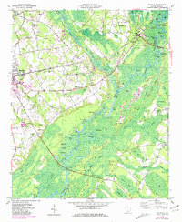 1948 Nichols1981 Print · USGSMarion and Horry counties are shown here at the mid-century, where the Little Pee Dee River meets the Lumber River. Researchers can trace the river economy through historic landings and crossings like Grice Ferry, Pitch Landing, and Sandy Bluff Bridge.
 - 1950 Map of Nichols
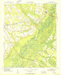 1950 Nichols1950 Print · USGSIn the mid-twentieth century, the Little Pee Dee River bottomlands shaped the communities of Mullins and Nichols. Local historians can trace early river crossings like Grice Ferry, rural church sites like Mt Zion Ch, and family landmarks across the Big Sand Hills Back Swamp.2 unique versions available
 - 1953 Map of Florence, 1964 Print
 1953 Florence1964 Print · USGSThe Carolina borderlands in the mid-fifties were a landscape of vast river swamps and rising rail towns. Trace the legacy of the Seaboard Air Line through Florence or explore the wetlands surrounding Lake Waccamaw and the Green Swamp.3 unique versions available
 - 1954 Map of Florence
 1954 Florence1954 Print · USGSThe Carolinas borderlands come alive in the early fifties, showing the vital rail-and-river networks of the coastal plain. Genealogists can trace family footprints across the Green Swamp or through settlements like Red Springs, Chadbourn, and McColl.
 - 1983 Map of Florence, 1985 Print
 1983 Florence1985 Print · USGSThe Pee Dee region in the early eighties shows a landscape shaped by river commerce and rail expansion. Researchers can trace historic river crossings at Galivants Ferry or locate vanished rail stops like Willow Creek Siding and Blue Brick.
End of results
Showing maps 1-7 of 7
Top cities near Mullins
- Marion historical maps
- Dillon historical maps
- Fair Bluff historical maps
- Lake View historical maps
- Aynor historical maps
- Nichols historical maps
See more
Top neighborhoods of Mullins
Frequently asked questions
- What are the different types of historical maps available for Mullins?
- What is the oldest map of Mullins?
- Where can I purchase historical maps of Mullins for my home or office?
- Where can I download high-res historical maps of Mullins?
- Are there historical topographic maps available for Mullins?
- Is there historical aerial imagery available for Mullins?
- Where are historical maps of Mullins sourced from?