1950s Maps of North Charleston, South Carolina
Explore 6 historic maps of North Charleston from the 1950s. These maps offer a rare glimpse into what life looked like during the 1950s — showing old roads, neighborhoods, homes, and landmarks that have changed or disappeared over time.
Whether you're researching your family's past, planning a metal detecting trip, or studying how North Charleston's landscape evolved across the 1950s, these high-resolution maps are a powerful tool for exploring the history of this region.
- Focus on a specific era: All maps on this page are from the 1950s, giving you a focused view of this time period.
- See what’s changed: Compare century-old streets, trails, and buildings to today's modern landscape using overlays and satellite layers.
- Research with precision: Use these maps for genealogy, historical research, land use analysis, or educational projects.
- View, download, or print: Maps are fully viewable online in high resolution, and can be downloaded or printed for your own records.
Start exploring North Charleston's history through authentic maps from the 1950s. This is your window into the past.
North Charleston, SC maps
(6)- 1957 Map of Stallsville, 1959 Print
 1957 Stallsville1959 Print · USGSThe Ashley River corridor and Dorchester County appear here in the late fifties as a landscape of colonial landmarks and private hunt clubs. Genealogists and historians can trace family-named sites such as St Lukes Ch, Old Fort Dorchester, and the riverfront at Middleton Gardens.3 unique versions available
 - 1957 Map of Savannah, 1967 Print
 1957 Savannah1967 Print · USGSThe Lowcountry and Georgia coastal plain are shown here in the late fifties, prior to modern expansion. Researchers can trace the rail-and-river economy through the Central of Georgia lines and the Ogeechee River wetlands.4 unique versions available
 - 1958 Map of North Charleston, 1959 Print
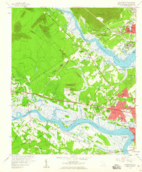
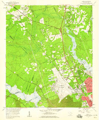
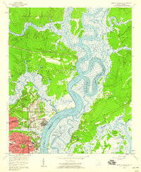 1958 North Charleston1959 Print · USGSNorth Charleston in the late fifties shows a booming industrial and military hub defined by its riverfront access. Researchers can trace the mid-century development of Park Circle, the massive Port Terminal, and community cornerstones like the Orphanage and Oak Terrace Sch.4 unique versions available
 - 1958 Map of Johns Island, 1959 Print
 1958 Johns Island1959 Print · USGSThe Lowcountry landscape west of Charleston comes to life in the late fifties, showing a mix of historic river estates and postwar growth. Genealogists and historians can trace local landmarks like Drayton Hall, Fort Bull, and the Stono Sta rail stop.5 unique versions available
 - 1958 Map of Charleston, 1959 Print
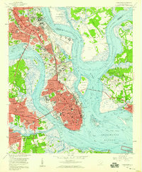 1958 Charleston1959 Print · USGSCharleston and its surrounding coastal islands are shown here in the late fifties as the city expanded northward and across its rivers. Researchers can locate long-standing institutions like The Citadel or trace family roots through historic sites like Magnolia Cem and Whipper Barony.5 unique versions available
 - 1958 Map of Ladson, 1959 Print
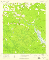
 1958 Ladson1959 Print · USGSCoastal South Carolina is captured here in a moment of rapid military and industrial growth during the late fifties. You can trace the expansion of North Charleston and the Charleston Air Force Base alongside historic riverfront landmarks like Magnolia Gardens.4 unique versions available
End of results
Showing maps 1-6 of 6
Top cities near North Charleston
- Charleston historical maps
- Mount Pleasant historical maps
- Summerville historical maps
- Goose Creek historical maps
- Hanahan historical maps
- Hollywood historical maps
See more
Top neighborhoods of North Charleston
- Ferndale historical maps
- Brentwood historical maps
- Pleasant Hills historical maps
- Evanston Estates historical maps
- Faber Place historical maps
- Fetteressa historical maps
See more
Frequently asked questions
- What are the different types of historical maps available for North Charleston?
- What is the oldest map of North Charleston?
- Where can I purchase historical maps of North Charleston for my home or office?
- Where can I download high-res historical maps of North Charleston?
- Are there historical topographic maps available for North Charleston?
- Is there historical aerial imagery available for North Charleston?
- Where are historical maps of North Charleston sourced from?