1980s Maps of Anderson Hills, Spartanburg County
Explore 4 historic maps of Anderson Hills from the 1980s. These maps offer a rare glimpse into what life looked like during the 1980s — showing old roads, neighborhoods, homes, and landmarks that have changed or disappeared over time.
Whether you're researching your family's past, planning a metal detecting trip, or studying how Anderson Hills's landscape evolved across the 1980s, these high-resolution maps are a powerful tool for exploring the history of this region.
- Focus on a specific era: All maps on this page are from the 1980s, giving you a focused view of this time period.
- See what’s changed: Compare century-old streets, trails, and buildings to today's modern landscape using overlays and satellite layers.
- Research with precision: Use these maps for genealogy, historical research, land use analysis, or educational projects.
- View, download, or print: Maps are fully viewable online in high resolution, and can be downloaded or printed for your own records.
Start exploring Anderson Hills's history through authentic maps from the 1980s. This is your window into the past.
Anderson Hills, Spartanburg County maps
(4)- 1983 Map of Reidville
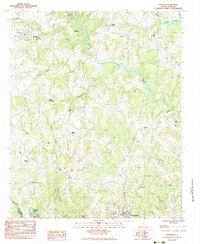 1983 Reidville1983 Print · USGSSpartanburg County in the early eighties shows a transition from rural crossroads to established small-town centers. Genealogists and historians can trace family roots through numerous local landmarks like Walkers Chapel, Dillard Crossroads, and Flint Hill Cem.
 - 1983 Map of Moore
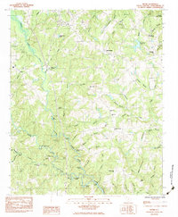 1983 Moore1983 Print · USGSSpartanburg County's river-carved landscape is documented here in the early eighties as the Tyger River forks define local life. Genealogists and historians can locate family landmarks like Walnut Grove Plantation, Cathcart Cem, and the Price Historical House.
 - 1984 Map of Greenville
 1984 Greenville1984 Print · USGSThe South Carolina Upstate undergoes rapid suburban growth in the mid-eighties as modern interstates begin to reshape the landscape. Researchers can trace historic rail lines like the Greenville and Northern Railway and locate local landmarks such as Clemson University and Paris Mountain State Park.
 - 1986 Map of Spartanburg
 1986 Spartanburg1986 Print · USGSUpstate South Carolina is captured here in the mid-1980s, showcasing the region's transition from a textile-driven rail corridor to a modern interstate hub. Researchers can trace the legacy of the SOUTHERN railroad through mill towns like Glendale or explore the wooded reaches of the Sumter National Forest.2 unique versions available
End of results
Showing maps 1-4 of 4
Frequently asked questions
- What are the different types of historical maps available for Anderson Hills?
- What is the oldest map of Anderson Hills?
- Where can I purchase historical maps of Anderson Hills for my home or office?
- Where can I download high-res historical maps of Anderson Hills?
- Are there historical topographic maps available for Anderson Hills?
- Is there historical aerial imagery available for Anderson Hills?
- Where are historical maps of Anderson Hills sourced from?