Old Maps of Sigsbee Farms, Spartanburg County for Genealogy
Trace your family roots with 17 historic maps of Sigsbee Farms. These high-res maps reveal old neighborhoods, homesites, landmarks, and streets — helping you uncover where your ancestors lived and how the area evolved over time.
- Explore historic neighborhoods: Identify where your relatives may have lived in the 1800s or 1900s.
- Compare maps over time: Trace the changes in streets, buildings, and landmarks for multi-generational research.
- Perfect for genealogy & ancestry research: Used by family historians and researchers to map out lineage and migration.
These maps are an incredible resource for exploring your personal connection to Sigsbee Farms's past.
Sigsbee Farms, Spartanburg County maps
(17)- 1935 Map of Greer
 1935 Greer1935 Print · USGSCovers Sigsbee Farms, including Greer, Simpsonville, and other nearby areas
 - 1938 Map of Greer
 1938 Greer1938 Print · USGSCovers Sigsbee Farms, including Greer, Simpsonville, and other nearby areas2 unique versions available
 - 1941 Map of Spartanburg
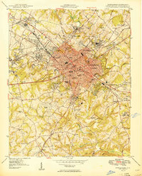
 1941 Spartanburg1941 Print · USGSCovers Sigsbee Farms, including Columbia, Rock Hill, and other nearby areas
 - 1947 Map of Spartanburg, 1969 Print
 1947 Spartanburg1969 Print · USGSCovers Sigsbee Farms, including Spartanburg, Pacolet, and other nearby areas
 - 1949 Map of Spartanburg
 1949 Spartanburg1949 Print · USGSCovers Sigsbee Farms, including Spartanburg, Roebuck, and other nearby areas3 unique versions available
 - 1949 Map of Spartanburg
 1949 Spartanburg1949 Print · USGSCovers Sigsbee Farms, including Spartanburg, Pacolet, and other nearby areas
 - 1953 Map of Spartanburg, 1966 Print
 1953 Spartanburg1966 Print · USGSCovers Sigsbee Farms, including Columbia, Rock Hill, and other nearby areas4 unique versions available
 - 1954 Map of Greenville, 1965 Print
 1954 Greenville1965 Print · USGSCovers Sigsbee Farms, including Athens, Greenville, and other nearby areas2 unique versions available
 - 1957 Map of Greer, 1959 Print
 1957 Greer1959 Print · USGSCovers Sigsbee Farms, including Greer, Simpsonville, and other nearby areas2 unique versions available
 - 1958 Map of Greenville
 1958 Greenville1958 Print · USGSCovers Sigsbee Farms, including Athens, Greenville, and other nearby areas
 - 1960 Map of Spartanburg
 1960 Spartanburg1960 Print · USGSCovers Sigsbee Farms, including Columbia, Rock Hill, and other nearby areas
 - 1964 Map of Spartanburg
 1964 Spartanburg1964 Print · USGSCovers Sigsbee Farms, including Columbia, Rock Hill, and other nearby areas
 - 1983 Map of Spartanburg
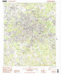 1983 Spartanburg1983 Print · USGSCovers Sigsbee Farms, including Spartanburg, Roebuck, and other nearby areas
 - 1983 Map of Wellford
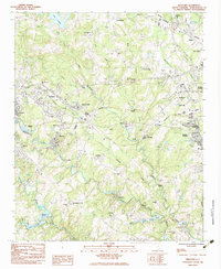 1983 Wellford1983 Print · USGSCovers Sigsbee Farms, including Lyman, Duncan, and other nearby areas
 - 1984 Map of Greenville
 1984 Greenville1984 Print · USGSCovers Sigsbee Farms, including Greenville, Greer, and other nearby areas
 - 1986 Map of Spartanburg
 1986 Spartanburg1986 Print · USGSCovers Sigsbee Farms, including Rock Hill, Spartanburg, and other nearby areas2 unique versions available
 - 1991 Map of Greenville
 1991 Greenville1991 Print · USGSCovers Sigsbee Farms, including Greenville, Greer, and other nearby areas
End of results
Showing maps 1-17 of 17
Frequently asked questions
- What are the different types of historical maps available for Sigsbee Farms?
- What is the oldest map of Sigsbee Farms?
- Where can I purchase historical maps of Sigsbee Farms for my home or office?
- Where can I download high-res historical maps of Sigsbee Farms?
- Are there historical topographic maps available for Sigsbee Farms?
- Is there historical aerial imagery available for Sigsbee Farms?
- Where are historical maps of Sigsbee Farms sourced from?