1970s Maps of York County, South Carolina
Explore 16 historic maps of York County from the 1970s. These maps offer a rare glimpse into what life looked like during the 1970s — showing old roads, neighborhoods, homes, and landmarks that have changed or disappeared over time.
Whether you're researching your family's past, planning a metal detecting trip, or studying how York County's landscape evolved across the 1970s, these high-resolution maps are a powerful tool for exploring the history of this region.
- Focus on a specific era: All maps on this page are from the 1970s, giving you a focused view of this time period.
- See what’s changed: Compare century-old streets, trails, and buildings to today's modern landscape using overlays and satellite layers.
- Research with precision: Use these maps for genealogy, historical research, land use analysis, or educational projects.
- View, download, or print: Maps are fully viewable online in high resolution, and can be downloaded or printed for your own records.
Start exploring York County's history through authentic maps from the 1970s. This is your window into the past.
York County, SC maps
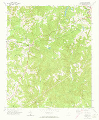
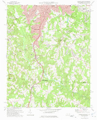
(16)- 1971 Map of Kings Mountain, 1973 Print
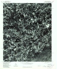
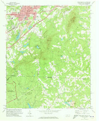 1971 Kings Mountain1973 Print · USGSThe foothills of the Carolinas come into focus during the early seventies as the industrial growth of Kings Mountain meets the preserved heights of the state and military parks. Researchers can trace the legacy of rural congregations and local landmarks like Pisgah Cem, Camp Rotary, and The Pinnacle.
 - 1971 Map of Filbert, 1973 Print
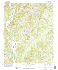
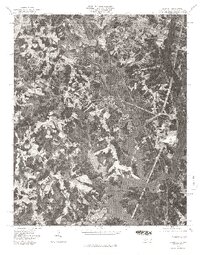
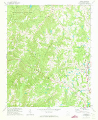 1971 Filbert1973 Print · USGSYork County in the early 1970s is shown here as a landscape of rural congregations and developing transportation hubs. Genealogists and historians can trace family locations through numerous landmarks like Mt Enon Ch, Lakeview Memory Gardens, and the Carolina and Northwestern rail line.
 - 1971 Map of Kings Creek, 1974 Print
 1971 Kings Creek1974 Print · USGSCherokee and York counties appear in the early seventies as a landscape of timbered parks, small rural junctions, and river industry. Genealogists can locate family landmarks like Oak Grove Ch, Mt Sinai Ch, and the community of Kings Creek.3 unique versions available
 - 1971 Map of Grover, 1974 Print
 1971 Grover1974 Print · USGSStraddling the Carolina state line in the early seventies, this region features a landscape of small rail-side settlements and rolling foothills. Genealogists and local historians can locate numerous country churches like St Peters Ch and Bethlehem Ch, as well as the Grover Cem.2 unique versions available
 - 1972 Map of Sharon, 1973 Print
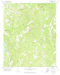
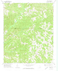
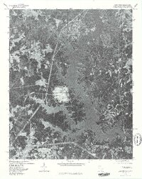
 1972 Sharon1973 Print · USGSThe rural crossroads of Sharon and the outskirts of York are captured here in the early 1970s. Local researchers can trace family roots through numerous country landmarks like Union Cem, Mt Carmel Ch, and the SOUTHERN railroad corridor.
 - 1972 Map of Hickory Grove, 1974 Print
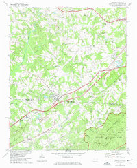
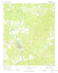
 1972 Hickory Grove1974 Print · USGSHickory Grove and the surrounding York County countryside are shown here in the early 1970s, as the railroad still shaped local commerce. Researchers can trace the heritage of rural congregations at Unity Ch, Salem Ch, and Shady Grove Ch, or locate old river crossings like Smith Ford.2 unique versions available
 - 1972 Map of Armenia, 1974 Print
 1972 Armenia1974 Print · USGSThe Chester County countryside near the York County line is captured here in the early seventies, centered on the communities of Armenia and Lowrys. Genealogists can trace numerous local landmarks including Old Providence Ch Cem, North Chester Sch, and Bethlehem Ch.
 - 1972 Map of Lockhart, 1975 Print
 1972 Lockhart1975 Print · USGSThe river-driven economies of the Carolina Piedmont are on display in the early 1970s at the confluence of the Broad River and Pacolet River. Genealogists and local historians can trace family-named landmarks and rural congregations like Mt Hopewell Ch, Bullock Creek, and the historic site of Pinckneyville.2 unique versions available
 - 1973 Map of Gastonia South, 1975 Print
 1973 Gastonia South1975 Print · USGSThe North Carolina and South Carolina borderlands south of Gastonia appear here in the early seventies, capturing the city's suburban reach and industrial growth. Researchers can trace family sites like Firestone Mem Cem or locate the Gastonia Airport and Bowling Green along the SOUTHERN rail line.
 - 1973 Map of Lake Wylie, 1976 Print
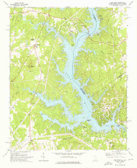 1973 Lake Wylie1976 Print · USGSThe Catawba River valley in the early seventies shows a landscape in transition between rural heritage and lakeside development. Researchers can trace the roots of shoreline communities like Tega Cay or locate historic country landmarks such as Bethel Mission and the York County Nature Museum.
 - 1973 Map of Belmont, 1976 Print
 1973 Belmont1976 Print · USGSThe industrial corridor of Gaston County comes to life in the early seventies, showing the textile centers and river life at the South Carolina border. Trace family roots at Bethesda Ch or Smith Cem, and locate landmarks like Sacred Heart College.
 - 1976 Map of Fort Mill, 1978 Print
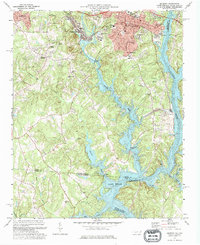
 1976 Fort Mill1978 Print · USGSThe South Carolina and North Carolina borderlands come into focus in the mid-seventies through this detailed aerial survey. Researchers can trace the development of Fort Mill and Pineville or locate the wooded reaches of Camp Cox along the Catawba R.
 - 1976 Map of Kings Mountain, 1978 Print
 1976 Kings Mountain1978 Print · USGSKings Mountain and the surrounding Piedmont landscape are captured in mid-1970s aerial detail, showing the era's mining and forest clearings. Trace early residential footprints near Mountain View or study the industrial sites near Kings Mountain and Lake York.
 - 1976 Map of Grover, 1978 Print
 1976 Grover1978 Print · USGSGrover and the surrounding Carolina borderlands are captured from above in the mid-1970s, showing the intersection of rural life and highway growth. Researchers can trace the development of Grover and Mudpine or follow the path of Buffalo Creek.
 - 1976 Map of Belmont, 1978 Print
 1976 Belmont1978 Print · USGSGaston County enters the late seventies with its textile towns expanding toward the water. Trace the shoreline of Lake Wylie and identify early suburban growth patterns near Belmont, Cramerton, and Elmore Crossroads.
 - 1976 Map of Lake Wylie, 1978 Print
 1976 Lake Wylie1978 Print · USGSThe developing shorelines of the South Carolina-North Carolina border are captured in this mid-seventies aerial study. Researchers can trace the early footprints of settlements like Pine Harbor and India Hook alongside the waters of Lake Wylie.
End of results
Showing maps 1-16 of 16
Top cities of York County
- Rock Hill historical maps
- Fort Mill historical maps
- Tega Cay historical maps
- Tega Cay historical maps
- York historical maps
- Baxter Village historical maps
See more
Frequently asked questions
- What are the different types of historical maps available for York County?
- What is the oldest map of York County?
- Where can I purchase historical maps of York County for my home or office?
- Where can I download high-res historical maps of York County?
- Are there historical topographic maps available for York County?
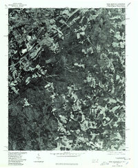
- Is there historical aerial imagery available for York County?
- Where are historical maps of York County sourced from?