1990s Maps of York County, South Carolina
Explore 9 historic maps of York County from the 1990s. These maps offer a rare glimpse into what life looked like during the 1990s — showing old roads, neighborhoods, homes, and landmarks that have changed or disappeared over time.
Whether you're researching your family's past, planning a metal detecting trip, or studying how York County's landscape evolved across the 1990s, these high-resolution maps are a powerful tool for exploring the history of this region.
- Focus on a specific era: All maps on this page are from the 1990s, giving you a focused view of this time period.
- See what’s changed: Compare century-old streets, trails, and buildings to today's modern landscape using overlays and satellite layers.
- Research with precision: Use these maps for genealogy, historical research, land use analysis, or educational projects.
- View, download, or print: Maps are fully viewable online in high resolution, and can be downloaded or printed for your own records.
Start exploring York County's history through authentic maps from the 1990s. This is your window into the past.
York County, SC maps
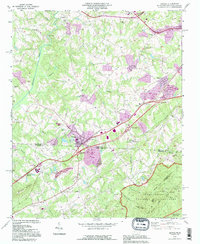
(9)- 1991 Map of Gastonia
 1991 Gastonia1991 Print · USGSThe Piedmont region along the North Carolina and South Carolina border shows a bustling industrial and transit corridor in the early nineties. Researchers can trace the sprawling footprints of Gastonia and Shelby or explore the grounds of Kings Mountain National Military Park and Lake Wylie.
 - 1993 Map of Grover, 1996 Print
 1993 Grover1996 Print · USGSThe North Carolina and South Carolina borderlands come into focus in the early nineties, centered on the community of Grover. Genealogists can trace family landmarks like Clingman Memorial Cem and Peoples Mission near the slopes of Whitaker Mountain.
 - 1993 Map of Lake Wylie, 1996 Print
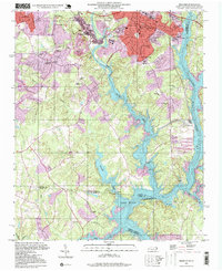
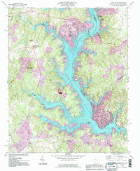 1993 Lake Wylie1996 Print · USGSThe Catawba River valley transitioned into a recreational hub in the late twentieth century as the shoreline of Lake Wylie became densely settled. Trace the development of communities like Tega Cay or locate historic rural landmarks like China Grove Ch and Nanny Mountain.
 - 1993 Map of Belmont, 1996 Print
 1993 Belmont1996 Print · USGSThe Gaston County textile belt and the waters of the Catawba River are captured here in the early nineties. Researchers can find deep local roots at Sacred Heart College, Elmores Crossroads, and the many family-named cemeteries like Smith Cem.
 - 1993 Map of Fort Mill, 1996 Print
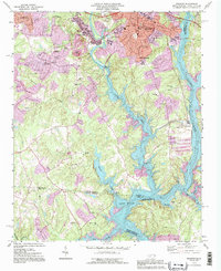
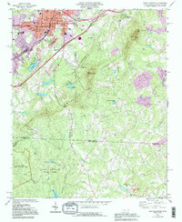
 1993 Fort Mill1996 Print · USGSThe Carolina borderlands north of Fort Mill were undergoing rapid suburban transformation in the early nineties as Charlotte expanded south. Genealogists and local historians can trace legacy sites like the James K. Polk Birthplace, Dinkins Cem, and McClintock Ch.2 unique versions available
 - 1993 Map of Kings Mountain, 1996 Print
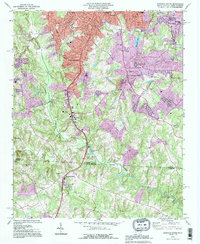
 1993 Kings Mountain1996 Print · USGSThe North and South Carolina borderlands come alive in this early 1990s survey, showing the deep connection between the Piedmont landscape and its industrial and military history. Genealogists and researchers can locate family landmarks like Pisgah Cem and Trinity Ch alongside industrial sites such as the Mine Shaft near Henry Knob.
 - 1993 Map of Gastonia South, 1996 Print
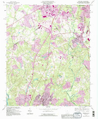
 1993 Gastonia South1996 Print · USGSThe North and South Carolina borderlands come into focus in the mid-nineties as Gastonia expands southward. Genealogists and local historians can trace family landmarks like Olney Ch, Firestone Mem Cem, and the old Dismantled Railroad corridor.
 - 1997 Map of Belmont, 1999 Print
 1997 Belmont1999 Print · USGSGaston and Mecklenburg counties are captured here in the late nineties as the river towns of Belmont and Cramerton expanded. Researchers can trace local heritage through numerous sites like Sacred Heart College, Elmores Crossroads, and the Mill Creek Cem.
 - 1997 Map of Kings Mountain, 2000 Print
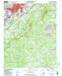 1997 Kings Mountain2000 Print · USGSThe foothills and high ridges of the Piedmont come into focus in the late nineties as industrial activity and conservation efforts met along the border. Local researchers can find family landmarks like Pisgah Cem, the Trinity Ch, and the prominent rise of The Pinnacle.
End of results
Showing maps 1-9 of 9
Top cities of York County
- Rock Hill historical maps
- Fort Mill historical maps
- Tega Cay historical maps
- Tega Cay historical maps
- York historical maps
- Baxter Village historical maps
See more
Frequently asked questions
- What are the different types of historical maps available for York County?
- What is the oldest map of York County?
- Where can I purchase historical maps of York County for my home or office?
- Where can I download high-res historical maps of York County?
- Are there historical topographic maps available for York County?
- Is there historical aerial imagery available for York County?
- Where are historical maps of York County sourced from?