1950s Maps of Gem Township, South Dakota
Explore 7 historic maps of Gem Township from the 1950s. These maps offer a rare glimpse into what life looked like during the 1950s — showing old roads, neighborhoods, homes, and landmarks that have changed or disappeared over time.
Whether you're researching your family's past, planning a metal detecting trip, or studying how Gem Township's landscape evolved across the 1950s, these high-resolution maps are a powerful tool for exploring the history of this region.
- Focus on a specific era: All maps on this page are from the 1950s, giving you a focused view of this time period.
- See what’s changed: Compare century-old streets, trails, and buildings to today's modern landscape using overlays and satellite layers.
- Research with precision: Use these maps for genealogy, historical research, land use analysis, or educational projects.
- View, download, or print: Maps are fully viewable online in high resolution, and can be downloaded or printed for your own records.
Start exploring Gem Township's history through authentic maps from the 1950s. This is your window into the past.
Gem Township, SD maps
(7)- 1953 Map of Stratford, 1955 Print
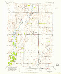 1953 Stratford1955 Print · USGSBrown County, South Dakota, is captured here in the mid-fifties as a thriving rail-and-river agricultural community centered on the town of Stratford. Researchers can trace the legacy of rural education and faith through landmarks like Sunnyview Sch, Midway Sch, and the local Lutheran Ch.
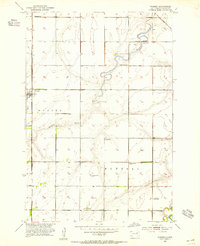
 - 1953 Map of Groton SW, 1955 Print
 1953 Groton SW1955 Print · USGSBrown County's agricultural heartland is captured here in the early fifties, showing a rural landscape organized by township sections. Genealogists can trace local history through a series of schoolhouses including Hanson Sch, School No 8, and the Minneapolis and St Louis railroad line.
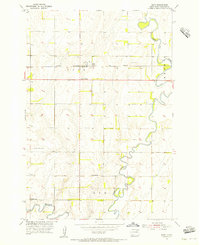
 - 1953 Map of Warner, 1955 Print
 1953 Warner1955 Print · USGSBrown County's rural townships are captured in the mid-1950s just as the Missouri River Basin development was underway. Genealogists can locate several local landmarks including Bright Star Sch, Happy Valley Sch, and the Warner townsite along the Milwaukee Road.
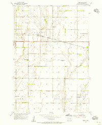
 - 1954 Map of Bath, 1955 Print
 1954 Bath1955 Print · USGSMid-century Brown County, South Dakota, reveals a landscape of prairie farms and river management. Trace rural life through the German Cem, local schoolhouses like Rainbow Sch, and the rail corridor of the Chicago Milwaukee St Paul and Pacific.2 unique versions available
 - 1954 Map of James, 1955 Print
 1954 James1955 Print · USGSBrown County's prairie landscape was dotted with family-named schoolhouses and rail sidings during the mid-1950s. Genealogists and local historians can trace specific community hubs like James, the Joan of Arc Sch, and the James Cemetery.2 unique versions available
 - 1954 Map of Aberdeen, 1964 Print
 1954 Aberdeen1964 Print · USGSNortheastern South Dakota in the mid-fifties remains a world of rail-dependent prairie towns and sweeping waterfowl refuges. Genealogists can trace family roots through settlements like Eureka and Ipswich or locate rural landmarks near Richmond Lake.2 unique versions available
 - 1956 Map of Aberdeen
 1956 Aberdeen1956 Print · USGSUpper South Dakota during the mid-fifties remains a landscape of rail-connected farming towns and expansive glacial lake basins. Genealogists and historians can trace the paths of the Minneapolis and St Louis railroad through Gettysburg or locate vanished stops near Elm Lake and Richmond Lake.
End of results
Showing maps 1-7 of 7
Top cities near Gem Township
- Aberdeen historical maps
- Bath historical maps
- Warner historical maps
- Ordway historical maps
- Mellette historical maps
- Hutterville Colony historical maps
See more
Top neighborhoods of Gem Township
Frequently asked questions
- What are the different types of historical maps available for Gem Township?
- What is the oldest map of Gem Township?
- Where can I purchase historical maps of Gem Township for my home or office?
- Where can I download high-res historical maps of Gem Township?
- Are there historical topographic maps available for Gem Township?
- Is there historical aerial imagery available for Gem Township?
- Where are historical maps of Gem Township sourced from?