Old Maps of Clay County, South Dakota
Explore 34 old maps of Clay County, spanning from 1897 to today. These high-resolution historic maps reveal how streets, neighborhoods, landmarks, and natural features evolved over time — perfect for genealogy, metal detecting, research, and local history exploration.
What you can do with these maps:
- See how Clay County changed over time: Compare historical maps to modern-day views to trace roads, homesites, rail lines & more.
- View detailed metadata: Each map includes creators, publishers, year, scale, and archive source.
- Overlay maps with satellite & LiDAR: Visualize the past alongside modern tools to explore terrain & human change.
- Trusted historical sources: Maps sourced from the USGS, Library of Congress, and other archives.
- Access maps your way: View online, download high-res files, or order prints for personal or research use.
Start exploring old maps of Clay County to uncover forgotten places, hidden landmarks, and the deep history beneath your feet.
Clay County, SD maps
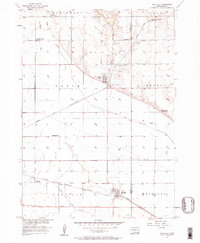
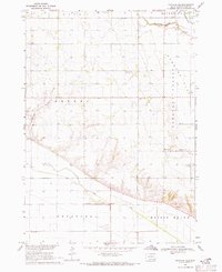
(34)- 1897 Map of Canton, 1954 Print
 1897 Canton1954 Print · USGSCovers Clay County, including Sioux Falls, Harrisburg, and other nearby areas
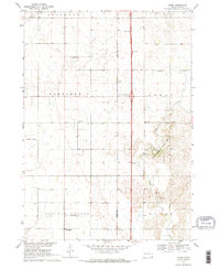
 - 1898 Map of Parker
 1898 Parker1898 Print · USGSCovers Clay County, including Freeman, Parker, and other nearby areas4 unique versions available
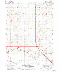
 - 1898 Map of Elk Point, 1960 Print
 1898 Elk Point1960 Print · USGSCovers Clay County, including Vermillion, Dakota Dunes, and other nearby areas2 unique versions available
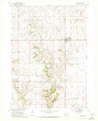
 - 1900 Map of Canton
 1900 Canton1900 Print · USGSCovers Clay County, including Sioux Falls, Harrisburg, and other nearby areas2 unique versions available
 - 1901 Map of Elk Point
 1901 Elk Point1901 Print · USGSCovers Clay County, including Vermillion, Dakota Dunes, and other nearby areas
 - 1907 Map of Elk Point
 1907 Elk Point1907 Print · USGSCovers Clay County, including Vermillion, Dakota Dunes, and other nearby areas6 unique versions available
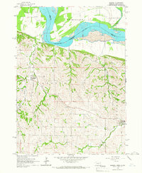
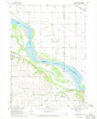
 - 1955 Map of Sioux City, 1959 Print
 1955 Sioux City1959 Print · USGSCovers Clay County, including Sioux City, Norfolk, and other nearby areas4 unique versions available
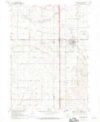
 - 1955 Map of Sioux Falls, 1967 Print
 1955 Sioux Falls1967 Print · USGSCovers Clay County, including Sioux Falls, Mitchell, and other nearby areas3 unique versions available
 - 1957 Map of Gayville, 1958 Print
 1957 Gayville1958 Print · USGSCovers Clay County, including Gayville, Volin, and other nearby areas
 - 1958 Map of Sioux City
 1958 Sioux City1958 Print · USGSCovers Clay County, including Sioux City, Norfolk, and other nearby areas
 - 1958 Map of Sioux Falls
 1958 Sioux Falls1958 Print · USGSCovers Clay County, including Sioux Falls, Mitchell, and other nearby areas
 - 1959 Map of Sioux City
 1959 Sioux City1959 Print · USGSCovers Clay County, including Sioux City, Norfolk, and other nearby areas
 - 1964 Map of Burbank, 1966 Print
 1964 Burbank1966 Print · USGSCovers Clay County, including Newcastle, Brule Township, and other nearby areas
 - 1964 Map of Maskell, 1966 Print
 1964 Maskell1966 Print · USGSCovers Clay County, including Newcastle, Maskell, and other nearby areas
 - 1968 Map of St. Helena, 1971 Print
 1968 St. Helena1971 Print · USGSCovers Clay County, including Saint Helena, St. Helena, and other nearby areas
 - 1968 Map of Beresford, 1971 Print
 1968 Beresford1971 Print · USGSCovers Clay County, including Beresford, Prairie Township, and other nearby areas
 - 1968 Map of Wakonda, 1971 Print
 1968 Wakonda1971 Print · USGSCovers Clay County, including Wakonda, Daneville Township, and other nearby areas
 - 1968 Map of Meckling, 1971 Print
 1968 Meckling1971 Print · USGSCovers Clay County, including Meckling, Precinct 6, and other nearby areas
 - 1968 Map of Centerville, 1971 Print
 1968 Centerville1971 Print · USGSCovers Clay County, including Centerville, Riverside Township, and other nearby areas
 - 1969 Map of Hub City, 1971 Print
 1969 Hub City1971 Print · USGSCovers Clay County, including Riverside Township, Glenwood Township, and other nearby areas
 - 1969 Map of Vermillion, 1971 Print
 1969 Vermillion1971 Print · USGSCovers Clay County, including Vermillion, Vermillion Township, and other nearby areas2 unique versions available
 - 1969 Map of Gayville NE, 1971 Print
 1969 Gayville NE1971 Print · USGSCovers Clay County, including Star Township, Riverside Township, and other nearby areas
 - 1969 Map of Alsen, 1971 Print
 1969 Alsen1971 Print · USGSCovers Clay County, including Hill Side, Prairie Township, and other nearby areas2 unique versions available
 - 1969 Map of Vermillion SE, 1971 Print
 1969 Vermillion SE1971 Print · USGSCovers Clay County, including Brule Township, Junction City, and other nearby areas
 - 1970 Map of Irene, 1972 Print
 1970 Irene1972 Print · USGSCovers Clay County, including Irene, Daneville Township, and other nearby areas
Showing maps 1-25 of 34
Frequently asked questions
- What are the different types of historical maps available for Clay County?
- What is the oldest map of Clay County?
- Where can I purchase historical maps of Clay County for my home or office?
- Where can I download high-res historical maps of Clay County?
- Are there historical topographic maps available for Clay County?
- Is there historical aerial imagery available for Clay County?
- Where are historical maps of Clay County sourced from?