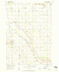
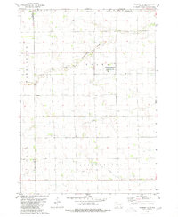
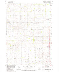
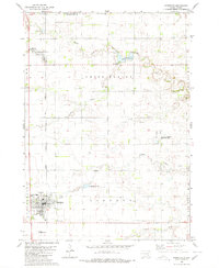
1900s (20th Century) Maps of Rome Township, South Dakota
Explore 13 historic maps of Rome Township from the 1900s (20th Century). These maps offer a rare glimpse into what life looked like during the 1900s — showing old roads, neighborhoods, homes, and landmarks that have changed or disappeared over time.
Whether you're researching your family's past, planning a metal detecting trip, or studying how Rome Township's landscape evolved across the 1900s, these high-resolution maps are a powerful tool for exploring the history of this region.
- Focus on a specific era: All maps on this page are from the 1900s, giving you a focused view of this time period.
- See what’s changed: Compare century-old streets, trails, and buildings to today's modern landscape using overlays and satellite layers.
- Research with precision: Use these maps for genealogy, historical research, land use analysis, or educational projects.
- View, download, or print: Maps are fully viewable online in high resolution, and can be downloaded or printed for your own records.
Start exploring Rome Township's history through authentic maps from the 1900s. This is your window into the past.
Rome Township, SD maps
(13)- 1955 Map of Sioux Falls, 1967 Print
 1955 Sioux Falls1967 Print · USGSThe eastern South Dakota and western Minnesota borderlands come alive in the mid-fifties, showing the vital rail-to-river connections of the era. Genealogists can trace family footprints across townships like Madison and Pipestone, while following the paths of the Big Sioux River and the Chicago and North Western line.3 unique versions available
 - 1955 Map of Mitchell, 1973 Print
 1955 Mitchell1973 Print · USGSThe Missouri River valley undergoes a massive transformation in the mid-1950s as the Fort Randall Dam creates Lake Francis Case. You can trace the rail lines of the Chicago Milwaukee St Paul and Pacific through Mitchell or locate local landmarks like Butler Town Hall.2 unique versions available
 - 1957 Map of Ethan, 1958 Print
 1957 Ethan1958 Print · USGSSouth Dakota's agricultural heartland is captured here in the mid-fifties, centered on the rail-aligned town of Ethan. Genealogists and historians can trace the transition of rural education via active and defunct sites like Coyne Sch and Clark Sch.
 - 1958 Map of Sioux Falls
 1958 Sioux Falls1958 Print · USGSThe tri-state borderlands of South Dakota, Minnesota, and Iowa are captured here during the mid-century peak of the regional rail network. Genealogists and historians can trace local landmarks like Augustana Academy, the St Marys Cem, and the path of the Illinois Central through Rock Rapids.
 - 1959 Map of Mitchell
 1959 Mitchell1959 Print · USGSSouth Dakota’s river and rail corridors come alive in the late fifties as the Missouri River valley undergoes dramatic change. Genealogists and historians can trace family roots through numerous small towns and schools such as Academy, Stickney, and Gregory.2 unique versions available
 - 1979 Map of Delmont NE, 1980 Print
 1979 Delmont NE1980 Print · USGSHutchinson County during the late 1970s reveals a quiet landscape of prairie townships and conserved wetlands. Genealogists and historians can trace family roots near Miller Cem or explore the drainage of Twelvemile Creek and the Starr National Waterfowl Production Area.
 - 1980 Map of Shoemaker Dam
 1980 Shoemaker Dam1980 Print · USGSDavison County townships were defined by their prairie watercourses and rail connections in the late twentieth century. Genealogists and researchers can locate the New Home Cemetery and follow the path of the C M St P & P railroad past Shoemaker Dam.
 - 1980 Map of Parkston
 1980 Parkston1980 Print · USGSHutchinson County agriculture and transport thrived in the 1970s as the rail line connected the grain-growing heartland. Researchers can locate family roots at SS Peter & Paul Cem, trace the waters of Lake Dimock, or follow the Chicago Milwaukee St Paul and Pacific tracks.
 - 1985 Map of Salem
 1985 Salem1985 Print · USGSEastern South Dakota’s prairie landscape is showcased in the mid-eighties, highlighting a region defined by agricultural colonies and rail-linked towns. Genealogists and historians can trace the foundations of Rosedale Colony, the Buffalo Trading Post, and early hubs like Salem.
 - 1985 Map of Freeman
 1985 Freeman1985 Print · USGSThe James River valley in the mid-1980s reveals a landscape of communal farming colonies and railroad-anchored prairie towns. Researchers can trace the layout of several Hutterite settlements like Maxwell Colony or locate local landmarks like Gagna Station and Turkey Ridge.2 unique versions available
 - 1986 Map of Mitchell
 1986 Mitchell1986 Print · USGSMitchell and the surrounding prairie towns are documented in the mid-1980s as the regional rail and agricultural network matured. Genealogists can locate specific sites like the State Training Sch, Aurora Center, and the Cedar Grove Colony.2 unique versions available
 - 1986 Map of Lake Andes
 1986 Lake Andes1986 Print · USGSThe Yankton Indian Reservation and the vast Missouri River impoundments define this South Dakota landscape in the mid-eighties. Researchers can trace old township lines and the Old Railroad Grade, or locate sites like Fort Randall and the Pleasant Ridge Cem.3 unique versions available
 - 1990 Map of Mitchell, 1991 Print
 1990 Mitchell1991 Print · USGSThe Missouri River and the surrounding South Dakota plains are captured here in the early nineties, showing a landscape shaped by water and wire. Genealogists and historians can trace the gridded townships from Mitchell to the Bijou Hills, locating sites like the Platte Colony and Academy.
End of results
Showing maps 1-13 of 13
Top cities near Rome Township
- Mitchell historical maps
- Parkston historical maps
- Ethan historical maps
- Dimock historical maps
- Milltown historical maps
- Fulton historical maps
Top neighborhoods of Rome Township
Frequently asked questions
- What are the different types of historical maps available for Rome Township?
- What is the oldest map of Rome Township?
- Where can I purchase historical maps of Rome Township for my home or office?
- Where can I download high-res historical maps of Rome Township?
- Are there historical topographic maps available for Rome Township?
- Is there historical aerial imagery available for Rome Township?
- Where are historical maps of Rome Township sourced from?