Old Maps of District 4, South Dakota
Explore 213 old maps of District 4, spanning from 1951 to today. These high-resolution historic maps reveal how streets, neighborhoods, landmarks, and natural features evolved over time — perfect for genealogy, metal detecting, research, and local history exploration.
What you can do with these maps:
- See how District 4 changed over time: Compare historical maps to modern-day views to trace roads, homesites, rail lines & more.
- View detailed metadata: Each map includes creators, publishers, year, scale, and archive source.
- Overlay maps with satellite & LiDAR: Visualize the past alongside modern tools to explore terrain & human change.
- Trusted historical sources: Maps sourced from the USGS, Library of Congress, and other archives.
- Access maps your way: View online, download high-res files, or order prints for personal or research use.
Start exploring old maps of District 4 to uncover forgotten places, hidden landmarks, and the deep history beneath your feet.
District 4, SD maps
(213)- 1951 Map of Ridgeview NW, 1953 Print
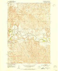
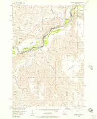
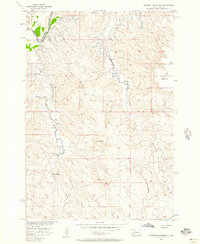
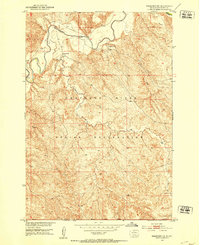 1951 Ridgeview NW1953 Print · USGSDewey County ranching and reservation lands are captured here in the early fifties during a period of Missouri River Basin development. Researchers can locate family landmarks like Ewing Ranch and Gunville Ranch along the banks of the Moreau River.3 unique versions available
 - 1951 Map of Ridgeview NE, 1953 Print
 1951 Ridgeview NE1953 Print · USGSThe Cheyenne River Indian Reservation is shown in the early fifties during a period of Missouri River Basin development. Researchers can trace rural landmarks like Bauer Sch and the drainage of Swan Creek and the Moreau R.3 unique versions available
 - 1952 Map of Whitehorse, 1954 Print
 1952 Whitehorse1954 Print · USGSThe Cheyenne River Indian Reservation and the settlement of Whitehorse are captured here in the early fifties during a period of Missouri River Basin development. Trace the rural landscape along the Moreau River to find local landmarks like the Cem and the Flowing Well.2 unique versions available
 - 1952 Map of Parade NE, 1954 Print
 1952 Parade NE1954 Print · USGSThe Cheyenne River Indian Reservation is captured in the early fifties as the Moreau River winds through the South Dakota prairie. Researchers can locate specific local landmarks such as On-a-Tree Ch and trace the paths of Redwater Creek and Goose Creek.2 unique versions available
 - 1952 Map of Lantry NE, 1954 Print
 1952 Lantry NE1954 Print · USGSThe Cheyenne River Indian Reservation and the winding Moreau River dominate this early 1950s survey of Dewey County. Genealogists and local historians can trace the settlement at Green Grass and the nearby Green Grass Cem.
 - 1952 Map of Parade NW, 1954 Print
 1952 Parade NW1954 Print · USGSDewey County’s prairie landscape is captured here in the early fifties, dominated by the winding Moreau River. Genealogists and researchers can trace the small community of Green Grass and locate industrial landmarks like the local Gravel Pits.2 unique versions available
 - 1952 Map of Glencross SE, 1954 Print
 1952 Glencross SE1954 Print · USGSThe Moreau River valley in Dewey County during the early fifties reveals a landscape of isolated missions and river crossings. Genealogists and historians can locate St Pauls Ch, Emmanuel Cem, and the historic Yellowhorse Ford along the winding river banks.2 unique versions available
 - 1953 Map of McIntosh, 1965 Print
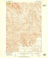
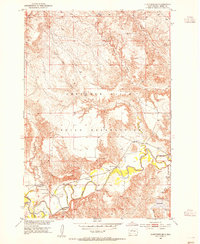
 1953 McIntosh1965 Print · USGSThe north-central Dakota prairie is captured here during the mid-fifties, showing the vast Standing Rock Indian Reservation and the newly formed Oah E Reservoir. Genealogists and historians can trace the Chicago Milwaukee St Paul and Pacific rail line through stops like McIntosh, Walker, and Eagle Butte.3 unique versions available
 - 1954 Map of Pierre, 1968 Print
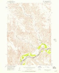
 1954 Pierre1968 Print · USGSThe Missouri River and the newly formed Oahe Reservoir define central South Dakota in the 1950s. Genealogists and local historians can trace early settlements and rail stops like Eakin Siding, Mission Ridge, and Ottumwa.2 unique versions available
 - 1955 Map of Rattlesnake Lake NE, 1956 Print
 1955 Rattlesnake Lake NE1956 Print · USGSZiebach County, South Dakota, is captured mid-century during a period of intensive Missouri River Basin development. Researchers can trace the rugged drainage patterns of Cherry Creek and follow the paths of Horn Draw and Straighthead Draw.
 - 1956 Map of Cherry Creek NW, 1957 Print
 1956 Cherry Creek NW1957 Print · USGSThe river valley along the Ziebach and Haakon county line is captured in the mid-1950s, showing the intersection of ranching and reservation land. Genealogists and historians can trace the legacy of local families at Red Fox Ranch, Motley Ranch, and White Cloud Ranch.2 unique versions available
 - 1956 Map of Carlin Flat, 1957 Print
 1956 Carlin Flat1957 Print · USGSMid-century ranching life in South Dakota centers on the winding Cheyenne River at the boundary of Haakon and Ziebach counties. Genealogists and local historians can trace family-named sites like Annis Ranch, the Carlin Sch, and the Buffalo Cem.2 unique versions available
 - 1956 Map of Alleman Station, 1957 Print
 1956 Alleman Station1957 Print · USGSHaakon and Ziebach counties appear here in the mid-1950s, just as the Missouri River Basin development began to reshape the Cheyenne River valley. Local historians can trace ranching history at Pearman Ranch or locate the community roots of Alleman Station and Dupree Ch.3 unique versions available
 - 1956 Map of Rousseau Creek SW, 1957 Print
 1956 Rousseau Creek SW1957 Print · USGSDewey and Stanley Counties are captured in the mid-1950s just before the landscape was altered by the Missouri River Basin development. Researchers can trace the riverfront holdings of Holloway Ranch, Chisholm Ranch, and the waters of Fishgut Creek.3 unique versions available
 - 1956 Map of Herbert Creek SE, 1957 Print
 1956 Herbert Creek SE1957 Print · USGSThe prairie landscape at the tri-county border of Dewey and Stanley was captured here in the mid-fifties, just before the Oahe Reservoir project altered the terrain. Researchers can trace the original courses of Herbert Creek and Paradis Creek or locate family-named landmarks like Gray Buttes and Kid Rich Flats.3 unique versions available
 - 1956 Map of Sansarc NE, 1957 Print
 1956 Sansarc NE1957 Print · USGSStanley and Dewey counties are captured here in the mid-fifties, just before the landscape was altered by the Oahe Reservoir project. Researchers can trace family ranch lands like Young Ranch and find remote burials at Walking Horse Cem or Lindsay Cem.3 unique versions available
 - 1956 Map of Crockett Mountains, 1957 Print
 1956 Crockett Mountains1957 Print · USGSStanley County ranch lands are documented here in the mid-fifties, showing the intersection of tribal and county borders along the Cheyenne River. Family history researchers can locate the Rousseau Cem and Webb Ranch among landmarks like Lindsay Butte.2 unique versions available
 - 1958 Map of Pierre
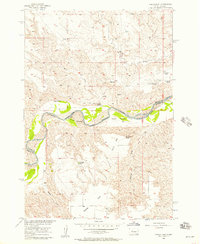
 1958 Pierre1958 Print · USGSCentral South Dakota is documented during the mid-fifties, just as the Missouri River valley was being transformed by the massive Oahe Dam project. Researchers can trace the early Oahe Reservoir shoreline and find remote outposts like Milesville, Onida, and Giddings Flat.
 - 1958 Map of McIntosh
 1958 McIntosh1958 Print · USGSThe north-central Dakotas appear here in the mid-1950s as massive engineering projects and rail lines shaped the plains. Researchers can trace tribal lands within the Standing Rock Indian Reservation and locate local landmarks like the Keller Mine or the Virginia Siding.
 - 1975 Map of Glencross, 1978 Print
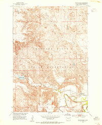
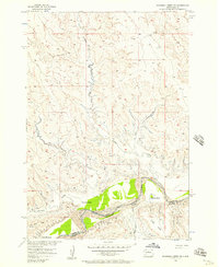
 1975 Glencross1978 Print · USGSDewey County, South Dakota, is captured here in the mid-1970s at the intersection of two major tribal lands. Researchers can trace the rail corridor of the Chicago Milwaukee St Paul and Pacific through Glencross and locate the Sacred Heart Cem.
 - 1975 Map of Trail City, 1978 Print
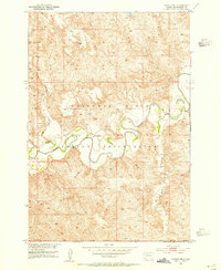
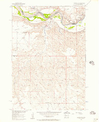
 1975 Trail City1978 Print · USGSTrail City in the mid-seventies occupies a unique position on the boundary between the Standing Rock and Cheyenne River Indian Reservations. Researchers can trace the path of the Chicago Milwaukee St Paul and Pacific railroad through the townsite and locate the Trail City Cem and Trail City Lake.
 - 1975 Map of Glencross NE, 1978 Print
 1975 Glencross NE1978 Print · USGSThe northern plains of South Dakota are captured in the mid-seventies, showing the intersection of tribal and county lands. Researchers can trace the path of the Chicago Milwaukee St Paul and Pacific rail line past Trail City RR Lake and the winding Handboy Creek.
 - 1978 Map of Brewer Butte, 1979 Print
 1978 Brewer Butte1979 Print · USGSNorth-central South Dakota is shown in the late seventies as the Chicago Milwaukee St Paul and Pacific railroad crossed the plains. Researchers can trace the winding Little Moreau River and find landmarks like Brewer Butte within the Standing Rock Indian Reservation.
 - 1978 Map of Timber Lake, 1979 Print
 1978 Timber Lake1979 Print · USGSTimber Lake and the surrounding plains of the Standing Rock Indian Reservation are captured here in the late seventies. Researchers can trace the Chicago Milwaukee St Paul and Pacific rail corridor or locate family sites at Holy Cross Cem and Timber Lake.2 unique versions available
 - 1978 Map of Peach Lake, 1979 Print
 1978 Peach Lake1979 Print · USGSDewey County’s high prairie and winding creek beds are meticulously documented in the late 1970s. Researchers can trace the seasonal waterways of Meadow Creek and Redwater Creek, or locate the specific topography surrounding Peach Lake.
Showing maps 1-25 of 213
Top neighborhoods of District 4
- Parade historical maps
- Firesteel historical maps
- Glencross historical maps
- Thatcher historical maps
- Yellowhorse Ford historical maps
- Lantry historical maps
See more
Frequently asked questions
- What are the different types of historical maps available for District 4?
- What is the oldest map of District 4?
- Where can I purchase historical maps of District 4 for my home or office?
- Where can I download high-res historical maps of District 4?
- Are there historical topographic maps available for District 4?
- Is there historical aerial imagery available for District 4?
- Where are historical maps of District 4 sourced from?