1950s Maps of Grant County, South Dakota
Explore 7 historic maps of Grant County from the 1950s. These maps offer a rare glimpse into what life looked like during the 1950s — showing old roads, neighborhoods, homes, and landmarks that have changed or disappeared over time.
Whether you're researching your family's past, planning a metal detecting trip, or studying how Grant County's landscape evolved across the 1950s, these high-resolution maps are a powerful tool for exploring the history of this region.
- Focus on a specific era: All maps on this page are from the 1950s, giving you a focused view of this time period.
- See what’s changed: Compare century-old streets, trails, and buildings to today's modern landscape using overlays and satellite layers.
- Research with precision: Use these maps for genealogy, historical research, land use analysis, or educational projects.
- View, download, or print: Maps are fully viewable online in high resolution, and can be downloaded or printed for your own records.
Start exploring Grant County's history through authentic maps from the 1950s. This is your window into the past.
Grant County, SD maps
(7)- 1953 Map of Ortonville, 1955 Print
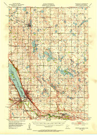 1953 Ortonville1955 Print · USGSThe Minnesota-South Dakota borderlands come alive in this mid-century survey of the lake-rich prairie. Genealogists and historians can locate numerous rural landmarks like Greenwood Cem, Pleasant Valley Ch, and the many numbered schools scattered between Clinton and Odessa.
 - 1953 Map of Bellingham, 1955 Print
 1953 Bellingham1955 Print · USGSThe borderlands of western Minnesota and South Dakota are shown here in the mid-fifties as a landscape of rail-connected prairie towns and a dense network of country school districts. Genealogists can trace family footprints near Bellingham and Marietta, or locate rural sites like Immanuel Ch and the Swedish Mission Cem.
 - 1953 Map of Milbank, 1958 Print
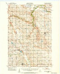
 1953 Milbank1958 Print · USGSThe tri-state border region of South Dakota, North Dakota, and Minnesota is shown here during the early fifties, a landscape defined by glacial lakes and the Sisseton Indian Reservation. Researchers can trace the legacy of the western railroads, locating old stops along the Great Northern and settlements like Milbank, Webster, and Sisseton.3 unique versions available
 - 1953 Map of Watertown, 1968 Print
 1953 Watertown1968 Print · USGSEastern South Dakota and the Minnesota borderlands are captured here during the mid-twentieth century as the region's agricultural and rail-service centers thrived. Genealogists and local historians can trace family-named sites across the Coteau des Prairies and find landmarks in Watertown, De Smet, and Brookings.3 unique versions available
 - 1954 Map of Big Stone Lake, 1956 Print
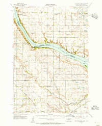 1954 Big Stone Lake1956 Print · USGSThe borderlands of Roberts County and Minnesota come into focus in the mid-1950s as rural school districts began to fade from the prairie. Trace the disappearance of early education at Golden Prairie Sch and School No 19, or locate family plots at Lakeside Cem and Effm Cem.2 unique versions available
 - 1958 Map of Milbank
 1958 Milbank1958 Print · USGSThe northern Great Plains in the late fifties show a landscape of glacial lakes and reservation lands shaped by the Great Northern railroad. Genealogists and local historians can trace the grid of settlements from Britton to Milbank and locate landmarks like Enemy Swim Lake and the Sisseton Indian Reservation.
 - 1958 Map of Watertown
 1958 Watertown1958 Print · USGSThe eastern South Dakota prairie and the Minnesota borderlands are captured here in the late fifties, showcasing a landscape of terminal moraine lakes and burgeoning rail hubs. Genealogists and historians can trace the early paths of the Chicago and North Western railroad or locate family roots in Watertown, Clark, or the Sisseton Indian Reservation.2 unique versions available
End of results
Showing maps 1-7 of 7
Top cities of Grant County
- Milbank historical maps
- Big Stone City historical maps
- Revillo historical maps
- Stockholm historical maps
- Troy historical maps
- Marvin historical maps
See more
Frequently asked questions
- What are the different types of historical maps available for Grant County?
- What is the oldest map of Grant County?
- Where can I purchase historical maps of Grant County for my home or office?
- Where can I download high-res historical maps of Grant County?
- Are there historical topographic maps available for Grant County?
- Is there historical aerial imagery available for Grant County?
- Where are historical maps of Grant County sourced from?