1960s Maps of Lake County, South Dakota
Explore 14 historic maps of Lake County from the 1960s. These maps offer a rare glimpse into what life looked like during the 1960s — showing old roads, neighborhoods, homes, and landmarks that have changed or disappeared over time.
Whether you're researching your family's past, planning a metal detecting trip, or studying how Lake County's landscape evolved across the 1960s, these high-resolution maps are a powerful tool for exploring the history of this region.
- Focus on a specific era: All maps on this page are from the 1960s, giving you a focused view of this time period.
- See what’s changed: Compare century-old streets, trails, and buildings to today's modern landscape using overlays and satellite layers.
- Research with precision: Use these maps for genealogy, historical research, land use analysis, or educational projects.
- View, download, or print: Maps are fully viewable online in high resolution, and can be downloaded or printed for your own records.
Start exploring Lake County's history through authentic maps from the 1960s. This is your window into the past.
Lake County, SD maps
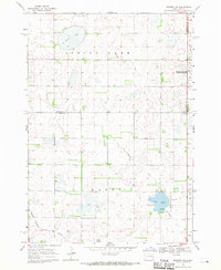
(14)- 1968 Map of Lake Madison, 1970 Print
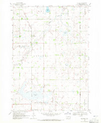
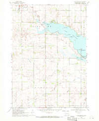 1968 Lake Madison1970 Print · USGSLake County's shoreline and prairie townships are captured here in the late sixties as the area's recreational and rural identity solidified. Genealogists and local researchers can locate St Thomas Cem, the settlement of Franklin, and the path of the Old Railroad Grade.
 - 1968 Map of Wentworth, 1970 Print
 1968 Wentworth1970 Print · USGSLake County at the end of the sixties reveals a transition from rail-dependent prairie towns to a landscape of conservation and recreation. Researchers can trace family plots at Rose Hill Cem and explore the historic rail corridors of the Great Northern and the C M ST P & P.
 - 1968 Map of Ramona, 1970 Print
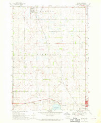 1968 Ramona1970 Print · USGSLake County agriculture and the rail-side life of the late sixties are preserved on this survey of the eastern South Dakota plains. Researchers can trace family sites near Ramona or locate local landmarks like the Drive-in Theater and Prairie Village.
 - 1968 Map of Madison, 1970 Print
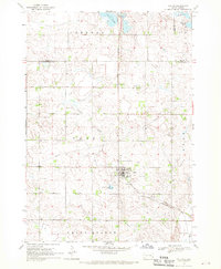
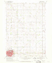 1968 Madison1970 Print · USGSMadison is shown as a thriving regional hub in the late sixties, centered on its college campus and railroad connections. Researchers can trace family roots through mapped landmarks like Graceland Cem, General Beadle State College, and Lake Madison Ch.
 - 1968 Map of Colton, 1970 Print
 1968 Colton1970 Print · USGSMinnehaha and Lake counties are shown here in the late sixties as the agricultural landscape of southeastern South Dakota continued its steady growth. Researchers can find numerous family-history sites like Taopi Cem and Huntimer or trace the Great Northern rail line.
 - 1968 Map of Sinai, 1970 Print
 1968 Sinai1970 Print · USGSThe prairie wetlands of Brookings and Lake Counties are captured here in the late sixties as agricultural life centered on the local rail line. Genealogists and historians can trace the foundations of Sinai and Nunda, locating rural landmarks like Ash Grove Cem and the central Townhall.
 - 1968 Map of Buffalo Trading Post, 1970 Print
 1968 Buffalo Trading Post1970 Print · USGSThe prairie lake country of Lake and Minnehaha counties is captured here in the late sixties, showing a landscape of rural homesteads and glacial waters. Genealogists can locate family landmarks like St Jacobs Cem, Bethany Cem, and the historic Buffalo Trading Post.
 - 1968 Map of Lake Madison SW, 1970 Print
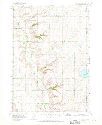 1968 Lake Madison SW1970 Print · USGSEastern McCook County and neighboring Lake County are shown in the late sixties as a landscape of river bends and rural townships. Researchers can find St Peters Ch, Ramsey Cem, and the old Townhall along the East Fork Vermillion River.
 - 1968 Map of Lake Herman, 1970 Print
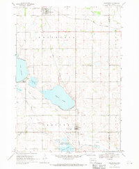
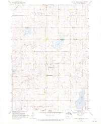
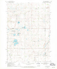
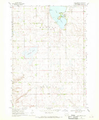 1968 Lake Herman1970 Print · USGSLake County, South Dakota, is captured here in the late sixties, showing a landscape defined by glacial sloughs and prairie agriculture. Genealogists and local historians can trace the rural infrastructure around Lake Herman, including Orland, Camp Lakodia, and the Cem near the banks of Silver Creek.
 - 1968 Map of Oldham, 1970 Print
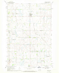 1968 Oldham1970 Print · USGSKingsbury County and the town of Oldham are shown during the late 1960s, capturing a traditional South Dakota prairie community linked by rail. Researchers can trace family sites at St Andreas Cem or Toles Cem and locate landmarks like the Townhall.
 - 1968 Map of Oldham SE, 1970 Print
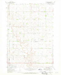 1968 Oldham SE1970 Print · USGSLake County prairie life in the late sixties is centered on the railroad town of Winifred and its surrounding wetlands. Genealogists and local historians can trace family locations near St Johns Ch, the Winfred Cem, and the winding East Fork Vermillion River.
 - 1968 Map of Madison NW, 1971 Print
 1968 Madison NW1971 Print · USGSLake County and Kingsbury County are captured in the late sixties at the height of their rail-and-water prairie character. Researchers can trace the Milwaukee Road rail line and locate St Anns Cem near the shores of Lake Badus.
 - 1968 Map of Rutland, 1971 Print
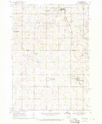
 1968 Rutland1971 Print · USGSThe prairie townships of Lake County were dominated by the rail-and-water landscape of the late sixties. Researchers can trace the Great Northern line through Rutland, locate the Lake Park Cem, and map the shores of Milwaukee Lake.
 - 1968 Map of Rutland NW, 1971 Print
 1968 Rutland NW1971 Print · USGSEastern South Dakota’s agricultural and wetland landscape is captured here in the late sixties, where the border of Lake and Brookings Counties meets. Genealogists can locate family landmarks such as Oslo Ch, Prairie Queen Cem, and the Townhall.2 unique versions available
End of results
Showing maps 1-14 of 14
Frequently asked questions
- What are the different types of historical maps available for Lake County?
- What is the oldest map of Lake County?
- Where can I purchase historical maps of Lake County for my home or office?
- Where can I download high-res historical maps of Lake County?
- Are there historical topographic maps available for Lake County?
- Is there historical aerial imagery available for Lake County?
- Where are historical maps of Lake County sourced from?