1960s Maps of Madison, Lakeview Township
Explore 4 historic maps of Madison from the 1960s. These maps offer a rare glimpse into what life looked like during the 1960s — showing old roads, neighborhoods, homes, and landmarks that have changed or disappeared over time.
Whether you're researching your family's past, planning a metal detecting trip, or studying how Madison's landscape evolved across the 1960s, these high-resolution maps are a powerful tool for exploring the history of this region.
- Focus on a specific era: All maps on this page are from the 1960s, giving you a focused view of this time period.
- See what’s changed: Compare century-old streets, trails, and buildings to today's modern landscape using overlays and satellite layers.
- Research with precision: Use these maps for genealogy, historical research, land use analysis, or educational projects.
- View, download, or print: Maps are fully viewable online in high resolution, and can be downloaded or printed for your own records.
Start exploring Madison's history through authentic maps from the 1960s. This is your window into the past.
Madison, Lakeview Township maps
(4)- 1968 Map of Lake Madison, 1970 Print
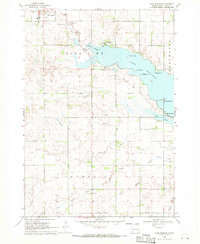 1968 Lake Madison1970 Print · USGSLake County's shoreline and prairie townships are captured here in the late sixties as the area's recreational and rural identity solidified. Genealogists and local researchers can locate St Thomas Cem, the settlement of Franklin, and the path of the Old Railroad Grade.
 - 1968 Map of Ramona, 1970 Print
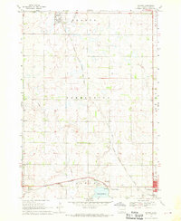 1968 Ramona1970 Print · USGSLake County agriculture and the rail-side life of the late sixties are preserved on this survey of the eastern South Dakota plains. Researchers can trace family sites near Ramona or locate local landmarks like the Drive-in Theater and Prairie Village.
 - 1968 Map of Madison, 1970 Print
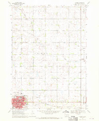 1968 Madison1970 Print · USGSMadison is shown as a thriving regional hub in the late sixties, centered on its college campus and railroad connections. Researchers can trace family roots through mapped landmarks like Graceland Cem, General Beadle State College, and Lake Madison Ch.
 - 1968 Map of Lake Herman, 1970 Print
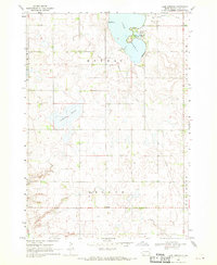 1968 Lake Herman1970 Print · USGSLake County, South Dakota, is captured here in the late sixties, showing a landscape defined by glacial sloughs and prairie agriculture. Genealogists and local historians can trace the rural infrastructure around Lake Herman, including Orland, Camp Lakodia, and the Cem near the banks of Silver Creek.
End of results
Showing maps 1-4 of 4
Top cities near Madison
- Chester historical maps
- Colton historical maps
- Franklin historical maps
- Rutland historical maps
- Ramona historical maps
- Oldham historical maps
See more
Frequently asked questions
- What are the different types of historical maps available for Madison?
- What is the oldest map of Madison?
- Where can I purchase historical maps of Madison for my home or office?
- Where can I download high-res historical maps of Madison?
- Are there historical topographic maps available for Madison?
- Is there historical aerial imagery available for Madison?
- Where are historical maps of Madison sourced from?