1930s Maps of Oacoma, South Dakota
Explore 2 historic maps of Oacoma from the 1930s. These maps offer a rare glimpse into what life looked like during the 1930s — showing old roads, neighborhoods, homes, and landmarks that have changed or disappeared over time.
Whether you're researching your family's past, planning a metal detecting trip, or studying how Oacoma's landscape evolved across the 1930s, these high-resolution maps are a powerful tool for exploring the history of this region.
- Focus on a specific era: All maps on this page are from the 1930s, giving you a focused view of this time period.
- See what’s changed: Compare century-old streets, trails, and buildings to today's modern landscape using overlays and satellite layers.
- Research with precision: Use these maps for genealogy, historical research, land use analysis, or educational projects.
- View, download, or print: Maps are fully viewable online in high resolution, and can be downloaded or printed for your own records.
Start exploring Oacoma's history through authentic maps from the 1930s. This is your window into the past.
Oacoma, SD maps
(2)- 1935 Map of Chamberlain, 1975 Print
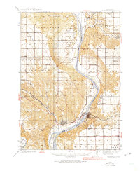 1935 Chamberlain1975 Print · USGSMid-century South Dakota river life centers on the Missouri crossing between Chamberlain and Oacoma during the mid-thirties. Genealogists can locate numerous country schools like Pleasant View Sch and historical sites such as the CCC Camp.
 - 1939 Map of Chamberlain
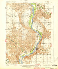 1939 Chamberlain1939 Print · USGSChamberlain and Oacoma face one another across the Missouri River in the late thirties, just as the region transitioned into the modern era. Genealogists and researchers can locate numerous country schools and churches, including St Albans Ch, Grace Mission Sch, and Riverview Cem.2 unique versions available
End of results
Showing maps 1-2 of 2
Top cities near Oacoma
- Chamberlain historical maps
- Pukwana historical maps
- Reliance historical maps
- Ideal Segment historical maps
- Ola historical maps
Frequently asked questions
- What are the different types of historical maps available for Oacoma?
- What is the oldest map of Oacoma?
- Where can I purchase historical maps of Oacoma for my home or office?
- Where can I download high-res historical maps of Oacoma?
- Are there historical topographic maps available for Oacoma?
- Is there historical aerial imagery available for Oacoma?
- Where are historical maps of Oacoma sourced from?