1960s Maps of McCook County, South Dakota
Explore 8 historic maps of McCook County from the 1960s. These maps offer a rare glimpse into what life looked like during the 1960s — showing old roads, neighborhoods, homes, and landmarks that have changed or disappeared over time.
Whether you're researching your family's past, planning a metal detecting trip, or studying how McCook County's landscape evolved across the 1960s, these high-resolution maps are a powerful tool for exploring the history of this region.
- Focus on a specific era: All maps on this page are from the 1960s, giving you a focused view of this time period.
- See what’s changed: Compare century-old streets, trails, and buildings to today's modern landscape using overlays and satellite layers.
- Research with precision: Use these maps for genealogy, historical research, land use analysis, or educational projects.
- View, download, or print: Maps are fully viewable online in high resolution, and can be downloaded or printed for your own records.
Start exploring McCook County's history through authentic maps from the 1960s. This is your window into the past.
McCook County, SD maps
(8)- 1964 Map of Montrose, 1966 Print
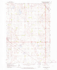
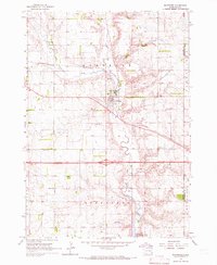 1964 Montrose1966 Print · USGSThe McCook County prairie centered on Montrose is captured here during the mid-1960s, showing a well-established network of farms and rail lines. Genealogists and local historians can locate St Patricks Cem, School No 39, and the winding East Fork Vermillion River.
 - 1964 Map of Canistota, 1966 Print
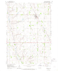 1964 Canistota1966 Print · USGSMcCook County agriculture and the rail-side growth of Canistota are captured here in the mid-sixties. Researchers can trace rural school districts and family burial sites like Rose Hill Cem, Riverside Ch, and the Ortman Landing Strip.
 - 1964 Map of Salem NE, 1966 Print
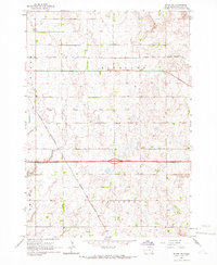 1964 Salem NE1966 Print · USGSMcCook County agriculture and rail travel are captured here in the mid-1960s. Researchers can trace the path of the CHICAGO AND NORTH WESTERN railroad or locate old rural school sites like School No 4 and School No 10.
 - 1964 Map of Salem, 1966 Print
 1964 Salem1966 Print · USGSMcCook County is captured in the mid-1960s, centered on the railroad hub of Salem. Local historians can trace early school sites like Herting Sch and family heritage at St Marys Cem or Wildwood Cem.
 - 1964 Map of Bridgewater East, 1966 Print
 1964 Bridgewater East1966 Print · USGSMcCook County is shown at the height of its mid-century rural development, anchored by the town of Bridgewater. Genealogists and historians can trace the locations of St Stephens Cem, early schoolhouses, and the diagonal Chicago Milwaukee St Paul and Pacific rail line.
 - 1964 Map of East Vermillion Lake, 1966 Print
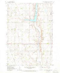 1964 East Vermillion Lake1966 Print · USGSMcCook County agriculture and water management are front and center in the mid-1960s as East Vermillion Lake fills the valley. Researchers can locate many rural landmarks including Spring Valley Cem and several numbered schoolhouses.
 - 1968 Map of Lake Madison SW, 1970 Print
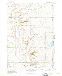 1968 Lake Madison SW1970 Print · USGSEastern McCook County and neighboring Lake County are shown in the late sixties as a landscape of river bends and rural townships. Researchers can find St Peters Ch, Ramsey Cem, and the old Townhall along the East Fork Vermillion River.
 - 1968 Map of Parker, 1971 Print
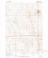
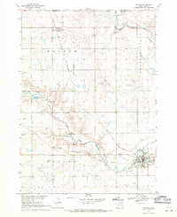 1968 Parker1971 Print · USGSParker and Monroe are captured in the late sixties at the convergence of two major rail lines and the forks of the Vermillion River. Researchers can locate the Thunder Valley Drag Strip, the Parker Valley Country Club, and several local cemeteries like Rose Hill Cem.
End of results
Showing maps 1-8 of 8
Frequently asked questions
- What are the different types of historical maps available for McCook County?
- What is the oldest map of McCook County?
- Where can I purchase historical maps of McCook County for my home or office?
- Where can I download high-res historical maps of McCook County?
- Are there historical topographic maps available for McCook County?
- Is there historical aerial imagery available for McCook County?
- Where are historical maps of McCook County sourced from?