1950s Maps of Summerset, South Dakota
Explore 5 historic maps of Summerset from the 1950s. These maps offer a rare glimpse into what life looked like during the 1950s — showing old roads, neighborhoods, homes, and landmarks that have changed or disappeared over time.
Whether you're researching your family's past, planning a metal detecting trip, or studying how Summerset's landscape evolved across the 1950s, these high-resolution maps are a powerful tool for exploring the history of this region.
- Focus on a specific era: All maps on this page are from the 1950s, giving you a focused view of this time period.
- See what’s changed: Compare century-old streets, trails, and buildings to today's modern landscape using overlays and satellite layers.
- Research with precision: Use these maps for genealogy, historical research, land use analysis, or educational projects.
- View, download, or print: Maps are fully viewable online in high resolution, and can be downloaded or printed for your own records.
Start exploring Summerset's history through authentic maps from the 1950s. This is your window into the past.
Summerset, SD maps
(5)- 1953 Map of Blackhawk, 1955 Print
 1953 Blackhawk1955 Print · USGSThe Black Hills eastern foothills meet the prairie in the early fifties, as the Chicago and North Western railroad dictates the pace of local life. Trace rural education and early roadside culture through Benoit Sch and the local Drive-in Theater.4 unique versions available
 - 1953 Map of Piedmont, 1955 Print
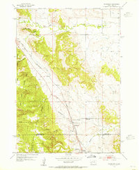
 1953 Piedmont1955 Print · USGSThe eastern front of the Black Hills is captured here during the mid-1950s as the rail-driven community of Piedmont meets the canyon lands. Researchers can trace deep-woods landmarks like Stagebarn Caverns, the Pinkerton Sch, and numerous mountain springs from Dody Spring to Dalton Lake.5 unique versions available
 - 1953 Map of Rapid City, 1964 Print
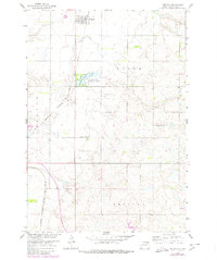
 1953 Rapid City1964 Print · USGSWestern South Dakota's transition from the Black Hills to the open prairie is captured here during the mid-fifties. Researchers can trace the development of Ellsworth Air Force Base alongside historic landmarks like Bear Butte and the Lower Alkali School.3 unique versions available
 - 1957 Map of Rapid City
 1957 Rapid City1957 Print · USGSWestern South Dakota in the mid-fifties reveals a landscape of high-altitude forests and growing military installations. Researchers can trace the development of Ellsworth Air Force Base, locate the Theodore Roosevelt Monument, and find rural landmarks like Lower Alkali School.
 - 1958 Map of Piedmont, 1980 Print
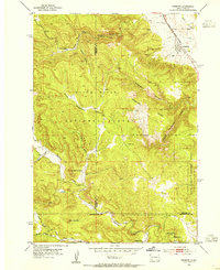
 1958 Piedmont1980 Print · USGSThe town of Pierpont and the surrounding prairie are captured here at the end of the 1950s. Genealogists and local historians can trace rural school locations like Union Prairie Sch and the path of the Chicago Milwaukee St Paul and Pacific railroad.
End of results
Showing maps 1-5 of 5
Top cities near Summerset
Frequently asked questions
- What are the different types of historical maps available for Summerset?
- What is the oldest map of Summerset?
- Where can I purchase historical maps of Summerset for my home or office?
- Where can I download high-res historical maps of Summerset?
- Are there historical topographic maps available for Summerset?
- Is there historical aerial imagery available for Summerset?
- Where are historical maps of Summerset sourced from?