1980s Maps of Coal Springs, South Dakota
Explore 2 historic maps of Coal Springs from the 1980s. These maps offer a rare glimpse into what life looked like during the 1980s — showing old roads, neighborhoods, homes, and landmarks that have changed or disappeared over time.
Whether you're researching your family's past, planning a metal detecting trip, or studying how Coal Springs's landscape evolved across the 1980s, these high-resolution maps are a powerful tool for exploring the history of this region.
- Focus on a specific era: All maps on this page are from the 1980s, giving you a focused view of this time period.
- See what’s changed: Compare century-old streets, trails, and buildings to today's modern landscape using overlays and satellite layers.
- Research with precision: Use these maps for genealogy, historical research, land use analysis, or educational projects.
- View, download, or print: Maps are fully viewable online in high resolution, and can be downloaded or printed for your own records.
Start exploring Coal Springs's history through authentic maps from the 1980s. This is your window into the past.
Coal Springs, SD maps
(2)- 1983 Map of Coal Springs, 1984 Print
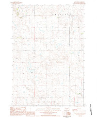 1983 Coal Springs1984 Print · USGSPerkins County in the early eighties is captured here as a landscape of remote ranches and expansive prairie drainages. Researchers can trace the legacy of rural flight and land use through landmarks like Coal Springs Dam, Nelson Airstrip, and the namesake Coal Springs settlement.
 - 1984 Map of Faith
 1984 Faith1984 Print · USGSWestern South Dakota's open plains and river breaks appear here in the mid-1980s, centered on the ranching country around Faith. Researchers can trace remote settlements and essential water infrastructure like Sorum, Bixby Gaging Station, and Mourine Lake.3 unique versions available
End of results
Showing maps 1-2 of 2
Top cities near Coal Springs
Frequently asked questions
- What are the different types of historical maps available for Coal Springs?
- What is the oldest map of Coal Springs?
- Where can I purchase historical maps of Coal Springs for my home or office?
- Where can I download high-res historical maps of Coal Springs?
- Are there historical topographic maps available for Coal Springs?
- Is there historical aerial imagery available for Coal Springs?
- Where are historical maps of Coal Springs sourced from?