1900s (20th Century) Maps of Summerville, South Dakota
Explore 5 historic maps of Summerville from the 1900s (20th Century). These maps offer a rare glimpse into what life looked like during the 1900s — showing old roads, neighborhoods, homes, and landmarks that have changed or disappeared over time.
Whether you're researching your family's past, planning a metal detecting trip, or studying how Summerville's landscape evolved across the 1900s, these high-resolution maps are a powerful tool for exploring the history of this region.
- Focus on a specific era: All maps on this page are from the 1900s, giving you a focused view of this time period.
- See what’s changed: Compare century-old streets, trails, and buildings to today's modern landscape using overlays and satellite layers.
- Research with precision: Use these maps for genealogy, historical research, land use analysis, or educational projects.
- View, download, or print: Maps are fully viewable online in high resolution, and can be downloaded or printed for your own records.
Start exploring Summerville's history through authentic maps from the 1900s. This is your window into the past.
Summerville, SD maps
(5)- 1954 Map of Lemmon, 1964 Print
 1954 Lemmon1964 Print · USGSThe high plains of South Dakota and North Dakota are documented here during the mid-twentieth century. Family researchers can trace dozens of country school sites like Green Cabin School and Bierke School alongside landmarks like The Castles.2 unique versions available
 - 1957 Map of Lemmon
 1957 Lemmon1957 Print · USGSThe northwestern plains of South Dakota and North Dakota are captured here in the mid-fifties, centered on the rail hub of Lemmon. Genealogists and historians can trace dozens of rural schoolhouses and vanished sites like Imogene and the Shadehill Reservoir area.
 - 1983 Map of Sommerville, 1984 Print
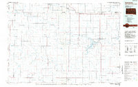
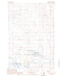 1983 Sommerville1984 Print · USGSPerkins County in the early eighties shows a landscape shaped by the Grand River and significant conservation efforts. Researchers can locate the expansive Shadehill Reservoir, the small settlement of Sommerville, and the local terrain of Ketterlings Point.
 - 1984 Map of Lemmon
 1984 Lemmon1984 Print · USGSThe High Plains borderlands of South Dakota and North Dakota are documented here in the mid-1980s, centered on the Lemmon and Hettinger rail corridor. Genealogists and historians can trace local landmarks like Strool, the Shadehill Reservoir shoreline, and isolated buttes including White Butte and Square Top Butte.2 unique versions available
 - 1998 Map of Summerville, 2001 Print
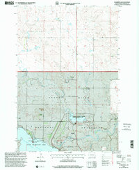 1998 Summerville2001 Print · USGSPerkins County ranch lands and the Grand River valley are captured here during the late nineties, showing a landscape defined by water and wide-open range. Genealogists and historians can trace family holdings like the Ham Ranch or E Erlenbusch Ranch and locate landmarks such as Summerville and the Shadehill Reservoir.
End of results
Showing maps 1-5 of 5
Top cities near Summerville
Frequently asked questions
- What are the different types of historical maps available for Summerville?
- What is the oldest map of Summerville?
- Where can I purchase historical maps of Summerville for my home or office?
- Where can I download high-res historical maps of Summerville?
- Are there historical topographic maps available for Summerville?
- Is there historical aerial imagery available for Summerville?
- Where are historical maps of Summerville sourced from?