1970s Maps of Old Agency District, South Dakota
Explore 10 historic maps of Old Agency District from the 1970s. These maps offer a rare glimpse into what life looked like during the 1970s — showing old roads, neighborhoods, homes, and landmarks that have changed or disappeared over time.
Whether you're researching your family's past, planning a metal detecting trip, or studying how Old Agency District's landscape evolved across the 1970s, these high-resolution maps are a powerful tool for exploring the history of this region.
- Focus on a specific era: All maps on this page are from the 1970s, giving you a focused view of this time period.
- See what’s changed: Compare century-old streets, trails, and buildings to today's modern landscape using overlays and satellite layers.
- Research with precision: Use these maps for genealogy, historical research, land use analysis, or educational projects.
- View, download, or print: Maps are fully viewable online in high resolution, and can be downloaded or printed for your own records.
Start exploring Old Agency District's history through authentic maps from the 1970s. This is your window into the past.
Old Agency District, SD maps
(10)- 1970 Map of Whitestone Lake, 1973 Print
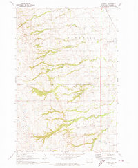
 1970 Whitestone Lake1973 Print · USGSThe Sisseton Indian Reservation during the 1970s shows a landscape of deep coulees and prairie lakes on the Coteau des Prairies. Researchers can trace rural cemetery sites like Spring Valley Cem and Roy Cem or locate local landmarks like St Benedict Ch.
 - 1970 Map of Sisseton, 1973 Print
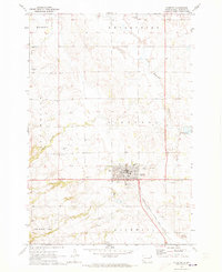 1970 Sisseton1973 Print · USGSThe Sisseton Indian Reservation during the early 1970s shows a landscape of rail-linked prairie towns and local landmarks. Trace family history at Saron Ch Cem or follow the Chicago Milwaukee St Paul and Pacific line past Dry Wood Lake.
 - 1970 Map of Summit NE, 1973 Print
 1970 Summit NE1973 Print · USGSNortheastern Roberts County in the early seventies reveals a landscape of glacial coulees and scattered prairie lakes. Genealogists can locate Old Ascension Cem and Ascension Ch near the deep drainage of Big Coulee.
 - 1970 Map of Wilmot NW, 1973 Print
 1970 Wilmot NW1973 Print · USGSRoberts County's prairie landscape was recorded in the early seventies, showing the intersection of rail history and reservation lands. You can trace the Chicago Milwaukee St Paul and Pacific line or locate the remote Boe Cem and Big Coulee.2 unique versions available
 - 1970 Map of Enemy Swim Lake East, 1973 Print
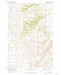
 1970 Enemy Swim Lake East1973 Print · USGSRoberts and Day County lands within the Sisseton Indian Reservation are captured here during the 1970s. Local researchers can map out rural intersections like Rudebusch Corner or trace the shorelines of Enemy Swim Lake and Hurricane Lake.
 - 1970 Map of Goodwill, 1973 Print
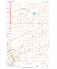
 1970 Goodwill1973 Print · USGSThe Sisseton Indian Reservation in the 1970s reveals a landscape of deep coulees and historic tribal centers. Genealogists can trace the Old Sisseton Indian Agency and the Goodwill Cem, or locate landmarks along the Chicago Milwaukee St Paul and Pacific line.
 - 1970 Map of Drywood Lakes, 1973 Print
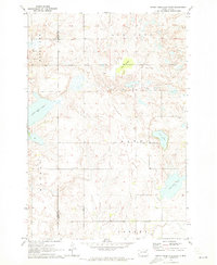
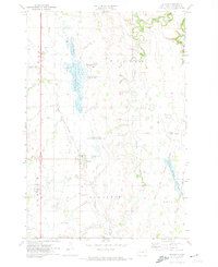
 1970 Drywood Lakes1973 Print · USGSThe Sisseton Indian Reservation in the early 1970s is characterized by its expansive prairie lakes and rural parish communities across Marshall and Roberts counties. Genealogists and local historians can locate remote landmarks like Zuark Ch, Buffalo Lake Ch, and the Townhall site.
 - 1971 Map of Peever, 1974 Print
 1971 Peever1974 Print · USGSNortheastern South Dakota in the early seventies shows a landscape of rail-connected prairie towns and extensive managed wetlands. Researchers can trace the Sisseton Indian Reservation Boundary and locate local landmarks like Peever Cem and the Townhall.
 - 1971 Map of Peever NW, 1974 Print
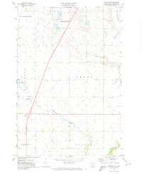 1971 Peever NW1974 Print · USGSRoberts County in the early seventies shows a landscape of prairie potholes and agricultural townships. Researchers can trace the Little Minnesota River and find local landmarks like Concordia Pioneer Ch and the Townhall.
 - 1979 Map of Sisseton, 1980 Print
 1979 Sisseton1980 Print · USGSNortheastern South Dakota and the North Dakota borderlands appear here in the late seventies, centered on the high glacial plateau. Genealogists and historians can trace the Sisseton Indian Reservation and rail-stop towns like Britton and Lake City.
End of results
Showing maps 1-10 of 10
Top cities near Old Agency District
- Sisseton historical maps
- Goodwill historical maps
- Waubay historical maps
- Wilmot historical maps
- Long Hollow historical maps
- Peever historical maps
See more
Top neighborhoods of Old Agency District
Frequently asked questions
- What are the different types of historical maps available for Old Agency District?
- What is the oldest map of Old Agency District?
- Where can I purchase historical maps of Old Agency District for my home or office?
- Where can I download high-res historical maps of Old Agency District?
- Are there historical topographic maps available for Old Agency District?
- Is there historical aerial imagery available for Old Agency District?
- Where are historical maps of Old Agency District sourced from?