1900s (20th Century) Maps of Jamesville Township, South Dakota
Explore 7 historic maps of Jamesville Township from the 1900s (20th Century). These maps offer a rare glimpse into what life looked like during the 1900s — showing old roads, neighborhoods, homes, and landmarks that have changed or disappeared over time.
Whether you're researching your family's past, planning a metal detecting trip, or studying how Jamesville Township's landscape evolved across the 1900s, these high-resolution maps are a powerful tool for exploring the history of this region.
- Focus on a specific era: All maps on this page are from the 1900s, giving you a focused view of this time period.
- See what’s changed: Compare century-old streets, trails, and buildings to today's modern landscape using overlays and satellite layers.
- Research with precision: Use these maps for genealogy, historical research, land use analysis, or educational projects.
- View, download, or print: Maps are fully viewable online in high resolution, and can be downloaded or printed for your own records.
Start exploring Jamesville Township's history through authentic maps from the 1900s. This is your window into the past.
Jamesville Township, SD maps
(7)- 1955 Map of Sioux Falls, 1967 Print
 1955 Sioux Falls1967 Print · USGSThe eastern South Dakota and western Minnesota borderlands come alive in the mid-fifties, showing the vital rail-to-river connections of the era. Genealogists can trace family footprints across townships like Madison and Pipestone, while following the paths of the Big Sioux River and the Chicago and North Western line.3 unique versions available
 - 1957 Map of Midway, 1958 Print
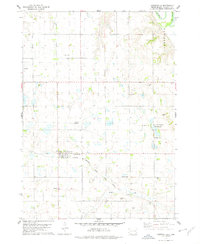
 1957 Midway1958 Print · USGSSoutheastern South Dakota in the late fifties is captured here as a landscape of section-line roads and prairie townships. Researchers can trace rural genealogy through numerous family-named landmarks and local institutions like Ulmer Cem, Bender Sch, and Bethlehem Ch.2 unique versions available
 - 1957 Map of Menno, 1958 Print
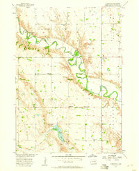
 1957 Menno1958 Print · USGSHutchinson County agriculture and river life are captured here in the mid-1950s as the regional rail network still anchored local trade. Researchers can locate numerous rural schools and churches, including Norway Sch, Ebenezer Ch, and the town of Menno.
 - 1957 Map of Jamesville, 1958 Print
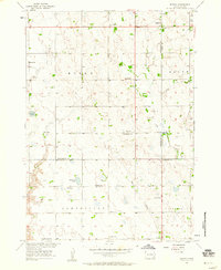
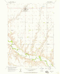
 1957 Jamesville1958 Print · USGSYankton County's rural townships are captured here in the late fifties, showing a landscape defined by the winding James River and its protective levee. Genealogists can locate numerous country schools and churches, including Anderson Sch, Martinus Ch, and Vedin Corner.
 - 1958 Map of Sioux Falls
 1958 Sioux Falls1958 Print · USGSThe tri-state borderlands of South Dakota, Minnesota, and Iowa are captured here during the mid-century peak of the regional rail network. Genealogists and historians can trace local landmarks like Augustana Academy, the St Marys Cem, and the path of the Illinois Central through Rock Rapids.
 - 1978 Map of Lesterville, 1979 Print
 1978 Lesterville1979 Print · USGSLesterville and the surrounding Yankton County prairie are shown here in the late seventies as the region maintained its agricultural and rail-dependent character. Researchers can trace historic family burial sites like Odessa Cem and Beadleston Cem or follow the Chicago Milwaukee St Paul and Pacific line.
 - 1985 Map of Freeman
 1985 Freeman1985 Print · USGSThe James River valley in the mid-1980s reveals a landscape of communal farming colonies and railroad-anchored prairie towns. Researchers can trace the layout of several Hutterite settlements like Maxwell Colony or locate local landmarks like Gagna Station and Turkey Ridge.2 unique versions available
End of results
Showing maps 1-7 of 7
Top cities near Jamesville Township
- Yankton historical maps
- Freeman historical maps
- Menno historical maps
- Tabor historical maps
- Mayfield historical maps
- Spring Valley historical maps
See more
Top neighborhoods of Jamesville Township
Frequently asked questions
- What are the different types of historical maps available for Jamesville Township?
- What is the oldest map of Jamesville Township?
- Where can I purchase historical maps of Jamesville Township for my home or office?
- Where can I download high-res historical maps of Jamesville Township?
- Are there historical topographic maps available for Jamesville Township?
- Is there historical aerial imagery available for Jamesville Township?
- Where are historical maps of Jamesville Township sourced from?