1930s Maps of Blowing Springs, Tennessee
Explore 2 historic maps of Blowing Springs from the 1930s. These maps offer a rare glimpse into what life looked like during the 1930s — showing old roads, neighborhoods, homes, and landmarks that have changed or disappeared over time.
Whether you're researching your family's past, planning a metal detecting trip, or studying how Blowing Springs's landscape evolved across the 1930s, these high-resolution maps are a powerful tool for exploring the history of this region.
- Focus on a specific era: All maps on this page are from the 1930s, giving you a focused view of this time period.
- See what’s changed: Compare century-old streets, trails, and buildings to today's modern landscape using overlays and satellite layers.
- Research with precision: Use these maps for genealogy, historical research, land use analysis, or educational projects.
- View, download, or print: Maps are fully viewable online in high resolution, and can be downloaded or printed for your own records.
Start exploring Blowing Springs's history through authentic maps from the 1930s. This is your window into the past.
Blowing Springs, TN maps
(2)- 1936 Map of Norris Dam
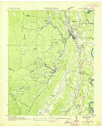
 1936 Norris Dam1936 Print · USGSIn the mid-thirties, the Clinch River valley underwent a total transformation as the new Norris Reservoir reshaped the land. Genealogists can trace family homesteads near Clinton, old burial sites like Leach Cem, and coal towns including Briceville.
 - 1936 Map of Coal Creek
 1936 Coal Creek1936 Print · USGSThe Tennessee coalfields are documented here in the mid-1930s, showing the industrial and social landscape of the Coal Creek valley. Family historians can trace local roots through landmarks like Miners Circle Cem, Briceville, and the Do Better Ch.2 unique versions available
End of results
Showing maps 1-2 of 2
Top cities near Blowing Springs
- Knoxville historical maps
- Oak Ridge historical maps
- Powell historical maps
- Halls Crossroads historical maps
- Clinton historical maps
- La Follette historical maps
See more
Frequently asked questions
- What are the different types of historical maps available for Blowing Springs?
- What is the oldest map of Blowing Springs?
- Where can I purchase historical maps of Blowing Springs for my home or office?
- Where can I download high-res historical maps of Blowing Springs?
- Are there historical topographic maps available for Blowing Springs?
- Is there historical aerial imagery available for Blowing Springs?
- Where are historical maps of Blowing Springs sourced from?