1930s Maps of Scenic Terrace, Maryville
Explore 2 historic maps of Scenic Terrace from the 1930s. These maps offer a rare glimpse into what life looked like during the 1930s — showing old roads, neighborhoods, homes, and landmarks that have changed or disappeared over time.
Whether you're researching your family's past, planning a metal detecting trip, or studying how Scenic Terrace's landscape evolved across the 1930s, these high-resolution maps are a powerful tool for exploring the history of this region.
- Focus on a specific era: All maps on this page are from the 1930s, giving you a focused view of this time period.
- See what’s changed: Compare century-old streets, trails, and buildings to today's modern landscape using overlays and satellite layers.
- Research with precision: Use these maps for genealogy, historical research, land use analysis, or educational projects.
- View, download, or print: Maps are fully viewable online in high resolution, and can be downloaded or printed for your own records.
Start exploring Scenic Terrace's history through authentic maps from the 1930s. This is your window into the past.
Scenic Terrace, Maryville maps
(2)- 1935 Map of Knoxville
 1935 Knoxville1935 Print · USGSKnoxville and its southern Blount County neighbors appear here in the mid-1930s as the TVA era begins. Researchers can trace family roots through Mt Olive Cem, locate the old Eastern State Hospital, or study the early layout of Sequoyah Hills.
 - 1935 Map of Maryville
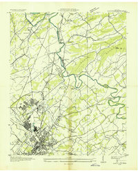 1935 Maryville1935 Print · USGSBlount County in the mid-1930s reveals a unique mix of industrial expansion and traditional rural life. Researchers can trace the early footprint of Alcoa and Maryville College, or locate family landmarks like Beech Grove Ch and Bungalow Town.
End of results
Showing maps 1-2 of 2
Top cities near Scenic Terrace
- Knoxville historical maps
- Maryville historical maps
- Oak Ridge historical maps
- Farragut historical maps
- Alcoa historical maps
- Louisville historical maps
See more
Frequently asked questions
- What are the different types of historical maps available for Scenic Terrace?
- What is the oldest map of Scenic Terrace?
- Where can I purchase historical maps of Scenic Terrace for my home or office?
- Where can I download high-res historical maps of Scenic Terrace?
- Are there historical topographic maps available for Scenic Terrace?
- Is there historical aerial imagery available for Scenic Terrace?
- Where are historical maps of Scenic Terrace sourced from?