1930s Maps of Cleveland, Tennessee
Explore 4 historic maps of Cleveland from the 1930s. These maps offer a rare glimpse into what life looked like during the 1930s — showing old roads, neighborhoods, homes, and landmarks that have changed or disappeared over time.
Whether you're researching your family's past, planning a metal detecting trip, or studying how Cleveland's landscape evolved across the 1930s, these high-resolution maps are a powerful tool for exploring the history of this region.
- Focus on a specific era: All maps on this page are from the 1930s, giving you a focused view of this time period.
- See what’s changed: Compare century-old streets, trails, and buildings to today's modern landscape using overlays and satellite layers.
- Research with precision: Use these maps for genealogy, historical research, land use analysis, or educational projects.
- View, download, or print: Maps are fully viewable online in high resolution, and can be downloaded or printed for your own records.
Start exploring Cleveland's history through authentic maps from the 1930s. This is your window into the past.
Cleveland, TN maps
(4)- 1935 Map of East Cleveland
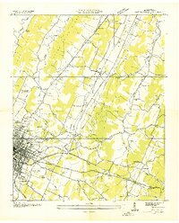 1935 East Cleveland1935 Print · USGSBradley County was a landscape of ridges and rail lines in the mid-1930s as the Tennessee Valley Authority began its regional work. Genealogists and local historians can trace family roots through numerous country landmarks like Hauns Mill, Julian Chapel, and the CCC Camp No 3466.
 - 1935 Map of Mc Donald
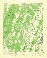
 1935 Mc Donald1935 Print · USGSDuring the mid-1930s, the rural Bradley County landscape was a network of ridge-top schools and valley rail stops. Researchers can trace family sites like Goats Chapel, the industry of Grumgoof Mill, and old settlements at Black Fox or Marble Switch.
 - 1935 Map of Felker
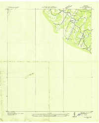 1935 Felker1935 Print · USGSEastern Bradley County was a network of rural creek valleys and community crossroads in the mid-1930s. Family historians can trace local landmarks like Taylors Sch, Kinsers Tabernacle, and the Union Grove Ch cemetery.
 - 1935 Map of South Cleveland
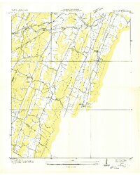
 1935 South Cleveland1935 Print · USGSSoutheast Tennessee in the mid-1930s is defined here by its ridge-and-valley landscape and rural crossroads. Genealogists and historians can locate family landmarks like Trues Chapel Cem, the Pentecostal Orphans Home, and Norman Chapel Sch.
End of results
Showing maps 1-4 of 4
Top cities near Cleveland
- Chattanooga historical maps
- Collegedale historical maps
- Benton historical maps
- Charleston historical maps
- Cohutta historical maps
- Calhoun historical maps
Top neighborhoods of Cleveland
- Mapleton Hills historical maps
- North Cleveland historical maps
- Sequoia Grove historical maps
- South Cleveland historical maps
- South Mapleton Hills historical maps
- Windwood historical maps
See more
Frequently asked questions
- What are the different types of historical maps available for Cleveland?
- What is the oldest map of Cleveland?
- Where can I purchase historical maps of Cleveland for my home or office?
- Where can I download high-res historical maps of Cleveland?
- Are there historical topographic maps available for Cleveland?
- Is there historical aerial imagery available for Cleveland?
- Where are historical maps of Cleveland sourced from?