1940s Maps of Cleveland, Tennessee
Explore 5 historic maps of Cleveland from the 1940s. These maps offer a rare glimpse into what life looked like during the 1940s — showing old roads, neighborhoods, homes, and landmarks that have changed or disappeared over time.
Whether you're researching your family's past, planning a metal detecting trip, or studying how Cleveland's landscape evolved across the 1940s, these high-resolution maps are a powerful tool for exploring the history of this region.
- Focus on a specific era: All maps on this page are from the 1940s, giving you a focused view of this time period.
- See what’s changed: Compare century-old streets, trails, and buildings to today's modern landscape using overlays and satellite layers.
- Research with precision: Use these maps for genealogy, historical research, land use analysis, or educational projects.
- View, download, or print: Maps are fully viewable online in high resolution, and can be downloaded or printed for your own records.
Start exploring Cleveland's history through authentic maps from the 1940s. This is your window into the past.
Cleveland, TN maps
(5)- 1940 Map of Mc Donald, 1956 Print
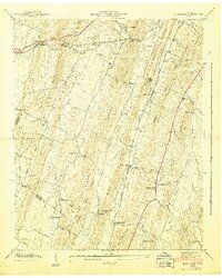
 1940 Mc Donald1956 Print · USGSThe rural ridges of Bradley and Hamilton County are captured here just before the war, when rail sidings and country schools anchored local life. Genealogists can locate family landmarks like Tucker Cem and Triplett Cem or trace the old Lee Highway corridor.
 - 1941 Map of Mc Donald
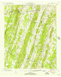
 1941 Mc Donald1941 Print · USGSIn the early 1940s, this Bradley County landscape was a network of ridgeline farms and rail-dependent hamlets. Researchers can trace the Southern Railway through McDonald or locate old community centers like Lebanon School and Bethel Ch.
 - 1943 Map of East Cleveland, 1946 Print
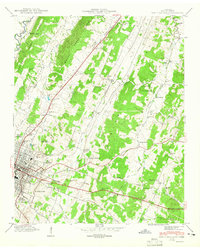 1943 East Cleveland1946 Print · USGSBradley County life in the early 1940s is detailed here as Cleveland expands along the Southern railroad. Researchers can trace family roots at Ramsey Cem or follow old school districts like Chatata Valley School and Valley Head School.2 unique versions available
 - 1943 Map of South Cleveland, 1946 Print
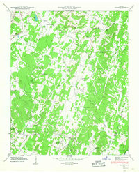
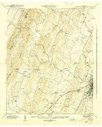 1943 South Cleveland1946 Print · USGSThe foothills of Bradley County come alive in this mid-1940s survey of the ridge-and-valley landscape around the Cleveland city limits. Genealogists and historians can trace the foundations of local society at the Pentecostal Orphanage, find the Lead Mine, or locate family burial grounds like Seaborn Cem.4 unique versions available
 - 1946 Map of Felker, 1947 Print
 1946 Felker1947 Print · USGSSoutheast Tennessee rural life is captured here in the mid-1940s, showing a landscape of ridge-top schools and creek-side churches. Genealogists can locate family landmarks like Kinser Tabernacle, Liberty Cem, and the small settlement of Pumpkin Center.2 unique versions available
End of results
Showing maps 1-5 of 5
Top cities near Cleveland
- Chattanooga historical maps
- Collegedale historical maps
- Benton historical maps
- Charleston historical maps
- Cohutta historical maps
- Calhoun historical maps
Top neighborhoods of Cleveland
- Mapleton Hills historical maps
- North Cleveland historical maps
- Sequoia Grove historical maps
- South Cleveland historical maps
- South Mapleton Hills historical maps
- Windwood historical maps
See more
Frequently asked questions
- What are the different types of historical maps available for Cleveland?
- What is the oldest map of Cleveland?
- Where can I purchase historical maps of Cleveland for my home or office?
- Where can I download high-res historical maps of Cleveland?
- Are there historical topographic maps available for Cleveland?
- Is there historical aerial imagery available for Cleveland?
- Where are historical maps of Cleveland sourced from?