1940s Maps of Eureka, Tennessee
Explore 2 historic maps of Eureka from the 1940s. These maps offer a rare glimpse into what life looked like during the 1940s — showing old roads, neighborhoods, homes, and landmarks that have changed or disappeared over time.
Whether you're researching your family's past, planning a metal detecting trip, or studying how Eureka's landscape evolved across the 1940s, these high-resolution maps are a powerful tool for exploring the history of this region.
- Focus on a specific era: All maps on this page are from the 1940s, giving you a focused view of this time period.
- See what’s changed: Compare century-old streets, trails, and buildings to today's modern landscape using overlays and satellite layers.
- Research with precision: Use these maps for genealogy, historical research, land use analysis, or educational projects.
- View, download, or print: Maps are fully viewable online in high resolution, and can be downloaded or printed for your own records.
Start exploring Eureka's history through authentic maps from the 1940s. This is your window into the past.
Eureka, TN maps
(2)- 1942 Map of Charleston, 1960 Print
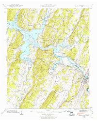 1942 Charleston1960 Print · USGSThe riverfront communities of Charleston and Calhoun are captured at a pivotal moment in the 1940s as the Hiwassee River meets the backwaters of the new reservoir. Researchers can trace the Southern railroad line and locate family-named sites like Godsey Cem and Blevins Chapel.2 unique versions available
 - 1943 Map of Charleston, 1946 Print
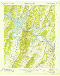 1943 Charleston1946 Print · USGSThe Tennessee riverfront and reservoir shoreline come alive in this mid-1940s survey of the Bradley and McMinn county lines. Genealogists can trace family roots at Maddux Cem, Mt Harmony Sch, and the riverside communities of Charleston and Calhoun.2 unique versions available
End of results
Showing maps 1-2 of 2
Top cities near Eureka
- Chattanooga historical maps
- Cleveland historical maps
- Athens historical maps
- Dayton historical maps
- Collegedale historical maps
- Graysville historical maps
See more
Frequently asked questions
- What are the different types of historical maps available for Eureka?
- What is the oldest map of Eureka?
- Where can I purchase historical maps of Eureka for my home or office?
- Where can I download high-res historical maps of Eureka?
- Are there historical topographic maps available for Eureka?
- Is there historical aerial imagery available for Eureka?
- Where are historical maps of Eureka sourced from?