1900s (20th Century) Maps of Jellico, Tennessee
Explore 7 historic maps of Jellico from the 1900s (20th Century). These maps offer a rare glimpse into what life looked like during the 1900s — showing old roads, neighborhoods, homes, and landmarks that have changed or disappeared over time.
Whether you're researching your family's past, planning a metal detecting trip, or studying how Jellico's landscape evolved across the 1900s, these high-resolution maps are a powerful tool for exploring the history of this region.
- Focus on a specific era: All maps on this page are from the 1900s, giving you a focused view of this time period.
- See what’s changed: Compare century-old streets, trails, and buildings to today's modern landscape using overlays and satellite layers.
- Research with precision: Use these maps for genealogy, historical research, land use analysis, or educational projects.
- View, download, or print: Maps are fully viewable online in high resolution, and can be downloaded or printed for your own records.
Start exploring Jellico's history through authentic maps from the 1900s. This is your window into the past.
Jellico, TN maps
(7)- 1953 Map of Jellico West, 1954 Print
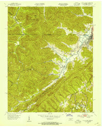 1953 Jellico West1954 Print · USGSThe Tennessee-Kentucky borderlands in the early fifties show a landscape shaped by coal and rail through the narrow valleys of the Cumberland. Trace the path of the Southern Railway past the Standard Mine and find family sites like the Black Oak Cem or the Zion Hill Sch & Ch.2 unique versions available
 - 1953 Map of Jellico East, 1955 Print
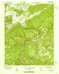 1953 Jellico East1955 Print · USGSThe Tennessee-Kentucky border comes alive in the early fifties, showing the mountain rail corridor before modern development. Genealogists can trace family roots at Bolton Cem or follow the old tracks through Morley and White Oak to find former schools like Ewing Sch.2 unique versions available
 - 1956 Map of Corbin, 1966 Print
 1956 Corbin1966 Print · USGSThe Kentucky and Tennessee borderlands are captured here in the mid-fifties, showing the region's shift toward modern interstate travel and reservoir development. Genealogists and historians can trace old community lines near Albany and Monticello or locate early rail junctions along the Southern and Tennessee Central lines.3 unique versions available
 - 1958 Map of Corbin
 1958 Corbin1958 Print · USGSThe Upper Cumberland borderlands appear in the late 1950s as massive reservoirs and early atomic-era growth reshape the region. Trace family roots and vanished landmarks near Lake Cumberland, Oak Ridge, and the Cumberland National Forest.
 - 1970 Map of Jellico East, 1972 Print
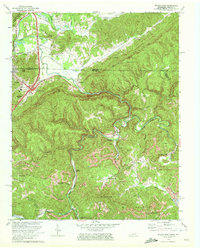 1970 Jellico East1972 Print · USGSThe Tennessee-Kentucky border comes alive in the early seventies, showing a landscape defined by coal mining and mountain rail lines. Genealogists and historians can trace families near Jellico, locate the Boston Sch, or find rural sites like Habersham and Walnut Grove Ch.3 unique versions available
 - 1979 Map of Jellico West, 1980 Print
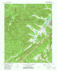 1979 Jellico West1980 Print · USGSMining and mountain life intersect along the Kentucky state line during the late seventies, where coal extraction shaped the local economy and geography. Researchers can find numerous family cemeteries like Lay Cem and landmarks such as the Stinking Creek Sch and Lookout Tower.2 unique versions available
 - 1981 Map of Corbin, 1984 Print
 1981 Corbin1984 Print · USGSThe Kentucky and Tennessee borderlands in the early eighties were characterized by coal towns and deep mountain ridges. Trace family history or rail routes through Stearns, Williamsburg, and the mining settlements near Jellico Mountain along the L & N RR.
End of results
Showing maps 1-7 of 7
Top cities near Jellico
- La Follette historical maps
- LaFollette historical maps
- Williamsburg historical maps
- Jacksboro historical maps
- Caryville historical maps
Frequently asked questions
- What are the different types of historical maps available for Jellico?
- What is the oldest map of Jellico?
- Where can I purchase historical maps of Jellico for my home or office?
- Where can I download high-res historical maps of Jellico?
- Are there historical topographic maps available for Jellico?
- Is there historical aerial imagery available for Jellico?
- Where are historical maps of Jellico sourced from?