1930s Maps of High Point, Tennessee
Explore 3 historic maps of High Point from the 1930s. These maps offer a rare glimpse into what life looked like during the 1930s — showing old roads, neighborhoods, homes, and landmarks that have changed or disappeared over time.
Whether you're researching your family's past, planning a metal detecting trip, or studying how High Point's landscape evolved across the 1930s, these high-resolution maps are a powerful tool for exploring the history of this region.
- Focus on a specific era: All maps on this page are from the 1930s, giving you a focused view of this time period.
- See what’s changed: Compare century-old streets, trails, and buildings to today's modern landscape using overlays and satellite layers.
- Research with precision: Use these maps for genealogy, historical research, land use analysis, or educational projects.
- View, download, or print: Maps are fully viewable online in high resolution, and can be downloaded or printed for your own records.
Start exploring High Point's history through authentic maps from the 1930s. This is your window into the past.
High Point, TN maps
(3)- 1935 Map of Rankin
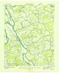 1935 Rankin1935 Print · USGSIn the mid-1930s, the river valleys of East Tennessee were still defined by small farming communities and country schools. Genealogists can trace family footprints at Atchleys Mill, Rorex Chapel, and the community of Rankin along the Southern railroad.
 - 1935 Map of Small
 1935 Small1935 Print · USGSEast Tennessee river life in the mid-1930s centered on the fertile valley between the Bays Mountains and the French Broad River. Researchers can trace ancestral locations at Mohawk, Parrottsville, and dozens of rural sites like Alshieys Mill or Bethesda Ch.
 - 1939 Map of Rankin
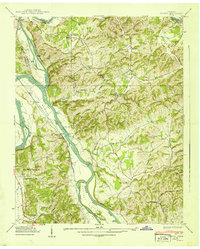 1939 Rankin1939 Print · USGSCocke County and its neighbors are captured here just before mid-century changes, showing the river-driven life along the French Broad River. Researchers can locate family landmarks like Atchley Mill, Solomon Ferry, and Redwine Cem.2 unique versions available
End of results
Showing maps 1-3 of 3
Top cities near High Point
- Morristown historical maps
- Newport historical maps
- Bean Station historical maps
- Dandridge historical maps
- White Pine historical maps
- Mosheim historical maps
See more
Frequently asked questions
- What are the different types of historical maps available for High Point?
- What is the oldest map of High Point?
- Where can I purchase historical maps of High Point for my home or office?
- Where can I download high-res historical maps of High Point?
- Are there historical topographic maps available for High Point?
- Is there historical aerial imagery available for High Point?
- Where are historical maps of High Point sourced from?