1960s Maps of Crockett County, Tennessee
Explore 7 historic maps of Crockett County from the 1960s. These maps offer a rare glimpse into what life looked like during the 1960s — showing old roads, neighborhoods, homes, and landmarks that have changed or disappeared over time.
Whether you're researching your family's past, planning a metal detecting trip, or studying how Crockett County's landscape evolved across the 1960s, these high-resolution maps are a powerful tool for exploring the history of this region.
- Focus on a specific era: All maps on this page are from the 1960s, giving you a focused view of this time period.
- See what’s changed: Compare century-old streets, trails, and buildings to today's modern landscape using overlays and satellite layers.
- Research with precision: Use these maps for genealogy, historical research, land use analysis, or educational projects.
- View, download, or print: Maps are fully viewable online in high resolution, and can be downloaded or printed for your own records.
Start exploring Crockett County's history through authentic maps from the 1960s. This is your window into the past.
Crockett County, TN maps
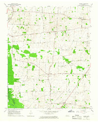
(7)- 1961 Map of Jones, 1963 Print
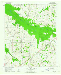 1961 Jones1963 Print · USGSHaywood and Crockett counties are captured here in the early sixties, a landscape defined by the winding South Fork Forked Deer River. Family researchers can trace ancestral locations near Owl City, Wortham Chapel Cemetery, and the Louisville and Nashville rail line.2 unique versions available
 - 1961 Map of Halls, 1965 Print
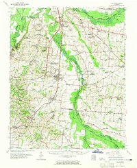 1961 Halls1965 Print · USGSLauderdale and Dyer counties are shown in the early sixties as the West Tennessee landscape hummed with activity along the Illinois Central tracks. Researchers can trace rural lineages through dozens of named sites like Miller Chapel Cem, Benton Sch, and the U. S. Military Reservation.
 - 1964 Map of Maury City, 1966 Print
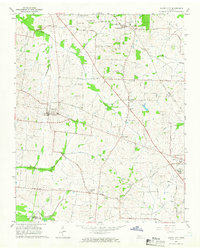 1964 Maury City1966 Print · USGSCrockett County life in the mid-1960s is centered on rural crossroads and the rail line connecting Maury City to Alamo. Researchers can trace family history through a network of local landmarks like Hamlett Robertson Sch and the Pond Creek Cem.2 unique versions available
 - 1964 Map of Alamo, 1966 Print
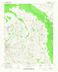
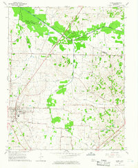 1964 Alamo1966 Print · USGSCrockett County in the mid-1960s was a landscape defined by its rail-connected town centers and fertile river bottoms. Local historians can trace the legacy of small communities like Coxville or find family roots at Quincy Cem and Mt Olive Ch.2 unique versions available
 - 1964 Map of Brazil, 1966 Print
 1964 Brazil1966 Print · USGSWest Tennessee rural life in the mid-sixties centered on crossroads communities and small parish churches across the Gibson and Crockett county lines. Genealogists can locate family landmarks like Walnut Grove Cem, the community of Frog Jump, and Doris Chapel.
 - 1965 Map of Friendship, 1967 Print
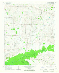
 1965 Friendship1967 Print · USGSCrockett County farm life and river-bottom landscapes are captured here in the mid-1960s. Genealogists can trace family connections through rural landmarks like Bethesda Ch, the rail siding at Tigrett, and the settlement of Elizabeth.2 unique versions available
 - 1965 Map of Tatumville, 1967 Print
 1965 Tatumville1967 Print · USGSDyer and Gibson Counties are shown here during the mid-1960s, defined by the winding course of the Forked Deer River. Researchers can trace ancestral locations near Tatumville, Churchton, and Atkins Cem, or locate rural churches such as Mt Tirzah Ch.2 unique versions available
End of results
Showing maps 1-7 of 7
Top cities of Crockett County
- Alamo historical maps
- Bells historical maps
- Maury City historical maps
- Friendship historical maps
- Gadsden historical maps
Frequently asked questions
- What are the different types of historical maps available for Crockett County?
- What is the oldest map of Crockett County?
- Where can I purchase historical maps of Crockett County for my home or office?
- Where can I download high-res historical maps of Crockett County?
- Are there historical topographic maps available for Crockett County?
- Is there historical aerial imagery available for Crockett County?
- Where are historical maps of Crockett County sourced from?