1930s Maps of Dyersburg, Tennessee
Explore 2 historic maps of Dyersburg from the 1930s. These maps offer a rare glimpse into what life looked like during the 1930s — showing old roads, neighborhoods, homes, and landmarks that have changed or disappeared over time.
Whether you're researching your family's past, planning a metal detecting trip, or studying how Dyersburg's landscape evolved across the 1930s, these high-resolution maps are a powerful tool for exploring the history of this region.
- Focus on a specific era: All maps on this page are from the 1930s, giving you a focused view of this time period.
- See what’s changed: Compare century-old streets, trails, and buildings to today's modern landscape using overlays and satellite layers.
- Research with precision: Use these maps for genealogy, historical research, land use analysis, or educational projects.
- View, download, or print: Maps are fully viewable online in high resolution, and can be downloaded or printed for your own records.
Start exploring Dyersburg's history through authentic maps from the 1930s. This is your window into the past.
Dyersburg, TN maps
(2)- 1939 Map of Dyersburg, 1943 Print
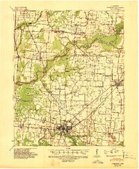 1939 Dyersburg1943 Print · USGSDyer and Obion Counties in the late thirties are shown here as a landscape of river-bottom farms and emerging rail hubs. Genealogists can trace family roots through numerous local landmarks like Springhill Ch & Cem, Viar Sch, and the Illinois Central corridor.2 unique versions available
 - 1939 Map of Halls, 1943 Print
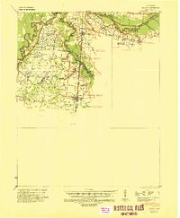 1939 Halls1943 Print · USGSLauderdale and Dyer Counties are mapped here during the late 1930s as the river-and-rail economy shaped West Tennessee life. Genealogists and researchers can trace the rural communities of Unionville, Fowlkes, and Key Corner, alongside landmark sites like Charles Chapel and the Nankipoo Sch.
End of results
Showing maps 1-2 of 2
Top cities near Dyersburg
- Newbern historical maps
- Halls historical maps
- Ridgely historical maps
- Obion historical maps
- Gates historical maps
- Maury City historical maps
See more
Top neighborhoods of Dyersburg
Frequently asked questions
- What are the different types of historical maps available for Dyersburg?
- What is the oldest map of Dyersburg?
- Where can I purchase historical maps of Dyersburg for my home or office?
- Where can I download high-res historical maps of Dyersburg?
- Are there historical topographic maps available for Dyersburg?
- Is there historical aerial imagery available for Dyersburg?
- Where are historical maps of Dyersburg sourced from?