1930s Maps of Blaine, Tennessee
Explore 5 historic maps of Blaine from the 1930s. These maps offer a rare glimpse into what life looked like during the 1930s — showing old roads, neighborhoods, homes, and landmarks that have changed or disappeared over time.
Whether you're researching your family's past, planning a metal detecting trip, or studying how Blaine's landscape evolved across the 1930s, these high-resolution maps are a powerful tool for exploring the history of this region.
- Focus on a specific era: All maps on this page are from the 1930s, giving you a focused view of this time period.
- See what’s changed: Compare century-old streets, trails, and buildings to today's modern landscape using overlays and satellite layers.
- Research with precision: Use these maps for genealogy, historical research, land use analysis, or educational projects.
- View, download, or print: Maps are fully viewable online in high resolution, and can be downloaded or printed for your own records.
Start exploring Blaine's history through authentic maps from the 1930s. This is your window into the past.
Blaine, TN maps
(5)- 1935 Map of Luttrell
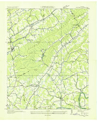 1935 Luttrell1935 Print · USGSRichland Valley and the surrounding ridges are captured in the mid-1930s as the river-and-rail economy thrived. Genealogists can trace family names through landmarks like Nances Ferry, Rush Strong Sch, and McKinney Cem.
 - 1935 Map of Mascot
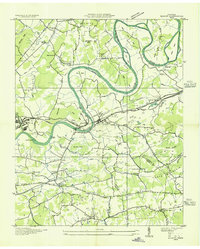 1935 Mascot1935 Print · USGSEast Tennessee during the mid-thirties reveals a landscape of river-bend farms and developing transit corridors along the Holston River. Genealogists and historians can trace family locations near Smith Mill, Howell Cem, and rural schoolhouses like Cynthiana Sch.
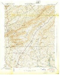
 - 1935 Map of Straw Plains
 1935 Straw Plains1935 Print · USGSEast Tennessee life in the mid-1930s is centered on the winding Holston River and the bustling Southern railroad corridor. Researchers can trace family roots at Hickle Cem, find the site of Massengale Mill, or locate Indian Cave.
 - 1938 Map of Mascot
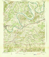 1938 Mascot1938 Print · USGSIn the late 1930s, the Holston River wound through a landscape of family-owned land and small railroad towns east of Knoxville. Researchers can trace ancestral roots through family-named landmarks like Crawford Cem and the Carter Mill.
 - 1939 Map of Luttrell
 1939 Luttrell1939 Print · USGSEast Tennessee ridge and valley life is captured here in the late thirties, from the ridges of Union County to the Holston River. Genealogists can trace family roots through sites like McKinney Cem, Nances Ferry, and the Rush Strong Sch.
End of results
Showing maps 1-5 of 5
Top cities near Blaine
- Knoxville historical maps
- Sevierville historical maps
- Halls Crossroads historical maps
- Jefferson City historical maps
- Maynardville historical maps
- Mascot historical maps
See more
Top neighborhoods of Blaine
Frequently asked questions
- What are the different types of historical maps available for Blaine?
- What is the oldest map of Blaine?
- Where can I purchase historical maps of Blaine for my home or office?
- Where can I download high-res historical maps of Blaine?
- Are there historical topographic maps available for Blaine?
- Is there historical aerial imagery available for Blaine?
- Where are historical maps of Blaine sourced from?