Old Maps of Grainger County, Tennessee for Metal Detecting
Plan your next treasure hunt with 101 historic maps of Grainger County. Find old homesites, ghost towns, trails, and gathering spots that may be lost to time — perfect for identifying promising metal detecting locations.
- Locate forgotten sites: Uncover places like long-lost settlements, abandoned rail lines, or gathering spots.
- Plan better hunts: Use map overlays combined with LiDAR or satellite views to narrow in on historically rich areas.
- Made for detectorists: Thousands of hobbyists use these maps to discover relics, coins, and hidden history.
Use these historic maps to boost your research and find new opportunities beneath the surface of Grainger County.
Grainger County, TN maps
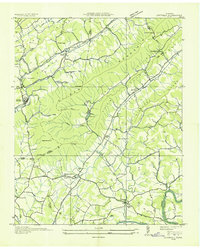
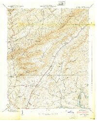
(101)- 1883 Map of Morristown
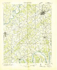
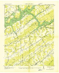
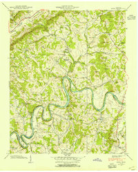
 1883 Morristown1883 Print · USGSEast Tennessee in the 1880s is defined by the convergence of mountain ridges and the vital rail corridor through Morristown. Researchers can trace the early industrial landscape of the region through landmarks like Witt's Foundry, Tate's Springs, and the historic Bean's Station.
 - 1893 Map of Morristown
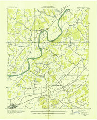
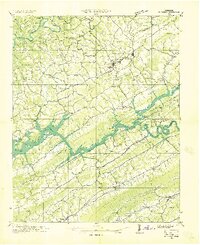
 1893 Morristown1893 Print · USGSEast Tennessee in the 1890s was a landscape of deep mountain ridges and vital rail junctions centered around Morristown. Researchers can trace the nineteenth-century river economy through numerous crossings like Cloud Ferry and find early industry at Lotspeachy Mill.
 - 1895 Map of Morristown
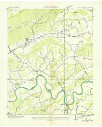
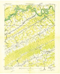
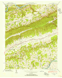
 1895 Morristown1895 Print · USGSThe East Tennessee ridge-and-valley country comes alive in the late nineteenth century as a hub of rail and river transit. Trace the routes of old Evans Ferry or locate vanished stops along the Southern R.R. near Morristown and Bull Gap.5 unique versions available
 - 1897 Map of Maynardville
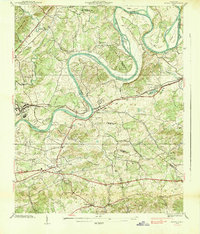
 1897 Maynardville1897 Print · USGSEast Tennessee in the late nineteenth century was a landscape of high ridges and vital river fords. Genealogists and historians can trace old homesteads and transit hubs like Nances Ferry, the Lead Mine at New Prospect, and Massongills Mill.
 - 1900 Map of Maynardville
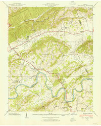
 1900 Maynardville1900 Print · USGSEast Tennessee was a world of river fords and mountain gaps at the turn of the century, dominated by the winding Clinch and Powell rivers. Genealogists can trace family roots through specific landmarks like Massongills Mill, Church Grove, and Sharps Chapel.4 unique versions available
 - 1935 Map of Luttrell
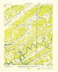
 1935 Luttrell1935 Print · USGSRichland Valley and the surrounding ridges are captured in the mid-1930s as the river-and-rail economy thrived. Genealogists can trace family names through landmarks like Nances Ferry, Rush Strong Sch, and McKinney Cem.
 - 1935 Map of Mascot
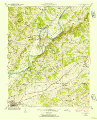
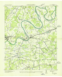 1935 Mascot1935 Print · USGSEast Tennessee during the mid-thirties reveals a landscape of river-bend farms and developing transit corridors along the Holston River. Genealogists and historians can trace family locations near Smith Mill, Howell Cem, and rural schoolhouses like Cynthiana Sch.
 - 1935 Map of Tate Springs
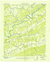
 1935 Tate Springs1935 Print · USGSThe river valleys of Grainger County are captured here in the mid-1930s as the Tennessee Valley Authority began planning the reservoir. Trace family history through local landmarks like Lawson Mill, Swan Island Ferry, and the community at Tate Springs.
 - 1935 Map of Straw Plains
 1935 Straw Plains1935 Print · USGSEast Tennessee life in the mid-1930s is centered on the winding Holston River and the bustling Southern railroad corridor. Researchers can trace family roots at Hickle Cem, find the site of Massengale Mill, or locate Indian Cave.
 - 1935 Map of Joppa
 1935 Joppa1935 Print · USGSThe rural Holston River valley comes to life in the mid-1930s, showing a landscape defined by family-named stores and river crossings. Genealogists and historians can trace local life through sites like Indian Cave Ferry, Haworth Cem, and CCC Camp No 8.
 - 1935 Map of Howard Quarter
 1935 Howard Quarter1935 Print · USGSClaiborne and Hancock counties are captured here in the mid-1930s as the Tennessee Valley Authority began its work on the Clinch River. Genealogists can trace family landmarks like Turner Cem, St Elmo Ch, and the site of CCC Camp No 27.
 - 1935 Map of Swan Island
 1935 Swan Island1935 Print · USGSHancock County life in the mid-1930s was defined by the ridges and the river, showing a landscape of small farms and vital ferry crossings. Researchers can trace ancestral footprints at Leffew Store, Ida Chapel, and the river landings at Swan Island Ferry.
 - 1935 Map of Avondale
 1935 Avondale1935 Print · USGSGrainger County is captured here in the mid-1930s as the rising Norris Reservoir began to reshape the landscape. Local historians can locate vanished landmarks like Avondale Sch, Shields Cem, and the original crossing at Turley Bridge.
 - 1935 Map of Bean Station
 1935 Bean Station1935 Print · USGSBean Station and the Holston River valley are captured in the mid-1930s, showing the region's rural character before modern development. Genealogists can locate family landmarks like the Caldwell Cem, Mullins Sch, and the Barnard Ch.
 - 1935 Map of Talbott
 1935 Talbott1935 Print · USGSThe rural river valley at the borders of Hamblen and Jefferson counties comes to life in this mid-1930s survey. Genealogists can locate family landmarks like the Martha Sunderland Cem, Wilson Cager Sch, and old river sites like Collins Ford.
 - 1935 Map of Dandridge
 1935 Dandridge1935 Print · USGSEast Tennessee in the mid-1930s is mapped here in great detail as the region's river valleys prepared for the impacts of the Tennessee Valley Authority. Researchers can trace ancestral locations through dozens of landmarks like Martha Sunderland Cem, Panther Creek Mill, and Roe Ch.
 - 1936 Map of Powder Springs
 1936 Powder Springs1936 Print · USGSNortheast of Knoxville in the mid-1930s, this area shows a landscape of deep valleys and rising water as the Norris Reservation took shape. Researchers can trace family sites like Haynes Store, rural schools including Lay Sch, and the Southern Railway line through Powder Springs.
 - 1936 Map of Rutledge
 1936 Rutledge1936 Print · USGSClinch River communities faced a major transformation in the mid-1930s as the new reservoir began to fill the valley. You can trace the pre-inundation landscape through landmarks like Beeler Mill, the Straight Creek Mines Sch, and Lone Mountain.
 - 1936 Map of Dutch Valley
 1936 Dutch Valley1936 Print · USGSGrainger County emerges in the mid-1930s as the Tennessee Valley Authority reshapes the landscape with the rising waters of Norris Reservoir. Genealogists and local historians can trace the foundations of Rutledge and Washburn alongside rural landmarks like Beeler Mill and Noe Chapel.
 - 1938 Map of Mascot
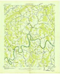
 1938 Mascot1938 Print · USGSIn the late 1930s, the Holston River wound through a landscape of family-owned land and small railroad towns east of Knoxville. Researchers can trace ancestral roots through family-named landmarks like Crawford Cem and the Carter Mill.
 - 1938 Map of Joppa, 1954 Print
 1938 Joppa1954 Print · USGSGrainger and Jefferson counties are captured here in the late 1930s, as the winding HOLSTON RIVER dictates the rhythm of rural life. Researchers can locate family roots at HAWORTH CEM, visit New Corinth Ch, or trace the legacy of CCC Camp No 8.
 - 1938 Map of Avondale, 1954 Print
 1938 Avondale1954 Print · USGSEast Tennessee's ridge-and-valley landscape is frozen in time during the late 1930s as the Tennessee Valley Authority began transforming the region's river systems. Researchers can trace ancestral locations through the Avondale Cem, local schools like Prospect Sch, and landmarks including Turley Mill and Idol Cross Roads.
 - 1938 Map of Bean Station, 1954 Print
 1938 Bean Station1954 Print · USGSUpper East Tennessee's ridges and river valleys are captured here in the late thirties, documenting the vital transit hub at Bean Station. Trace the legacy of rural communities through sites like Tate Springs, Kirkham Sch, and the Holston Bridge.2 unique versions available
 - 1938 Map of Talbott, 1954 Print
 1938 Talbott1954 Print · USGSEast Tennessee in the late thirties shows a landscape of river-bend farms and small rail towns along the Southern line. Genealogists and historians can trace family locations near Old Hull Mill, Kidwell Sch, or the C C C Camp at the edge of town.
 - 1939 Map of Luttrell
 1939 Luttrell1939 Print · USGSEast Tennessee ridge and valley life is captured here in the late thirties, from the ridges of Union County to the Holston River. Genealogists can trace family roots through sites like McKinney Cem, Nances Ferry, and the Rush Strong Sch.
Showing maps 1-25 of 101
Top cities of Grainger County
Frequently asked questions
- What are the different types of historical maps available for Grainger County?
- What is the oldest map of Grainger County?
- Where can I purchase historical maps of Grainger County for my home or office?
- Where can I download high-res historical maps of Grainger County?
- Are there historical topographic maps available for Grainger County?
- Is there historical aerial imagery available for Grainger County?
- Where are historical maps of Grainger County sourced from?