1930s Maps of Staunton Mill, Tennessee
Explore 2 historic maps of Staunton Mill from the 1930s. These maps offer a rare glimpse into what life looked like during the 1930s — showing old roads, neighborhoods, homes, and landmarks that have changed or disappeared over time.
Whether you're researching your family's past, planning a metal detecting trip, or studying how Staunton Mill's landscape evolved across the 1930s, these high-resolution maps are a powerful tool for exploring the history of this region.
- Focus on a specific era: All maps on this page are from the 1930s, giving you a focused view of this time period.
- See what’s changed: Compare century-old streets, trails, and buildings to today's modern landscape using overlays and satellite layers.
- Research with precision: Use these maps for genealogy, historical research, land use analysis, or educational projects.
- View, download, or print: Maps are fully viewable online in high resolution, and can be downloaded or printed for your own records.
Start exploring Staunton Mill's history through authentic maps from the 1930s. This is your window into the past.
Staunton Mill, TN maps
(2)- 1936 Map of Lake Davy Crockett
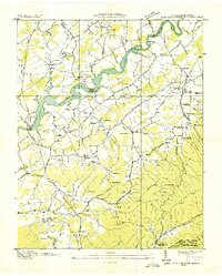 1936 Lake Davy Crockett1936 Print · USGSGreene County is documented here during the mid-1930s as new reservoirs began to alter the river valleys. Local historians can trace the foundations of many vanished community sites, from the Cove Creek Mill to the Tobacco Experimental Station and the original Birds Bridge.
 - 1939 Map of Davy Crockett Lake, 1956 Print
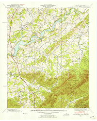 1939 Davy Crockett Lake1956 Print · USGSIn the late 1930s, this Greene County landscape was dominated by the waters of Davy Crockett Lake and the rugged boundary of the Bald Mountains. Researchers can trace old family sites and community roots through landmarks like Staunton Mill, Price Cem, and the path of Lonesome Pine Trail.5 unique versions available
End of results
Showing maps 1-2 of 2
Top cities near Staunton Mill
- Greeneville historical maps
- Tusculum historical maps
- Mosheim historical maps
- Bulls Gap historical maps
- Hot Springs historical maps
- Baileyton historical maps
Frequently asked questions
- What are the different types of historical maps available for Staunton Mill?
- What is the oldest map of Staunton Mill?
- Where can I purchase historical maps of Staunton Mill for my home or office?
- Where can I download high-res historical maps of Staunton Mill?
- Are there historical topographic maps available for Staunton Mill?
- Is there historical aerial imagery available for Staunton Mill?
- Where are historical maps of Staunton Mill sourced from?