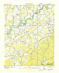
1936 Map of Lake Davy Crockett
USGS Topo · Published 1936About this map
Lake Davy Crockett and the winding Nolichucky River dominate this 1936 landscape, a time when the Tennessee Valley Authority was actively reshaping the region's waterways. The map reveals a dense network of rural community centers, including the Tobacco Experimental Station and numerous small-scale educational sites like Links Sch and Harrisons Sch. The era's transportation infrastructure is marked by the Lonesome Pine Trail and Birds Bridge, which facilitated movement across the river's various islands like Johnson Island.
Find a feature on this map
74 named features on this map. Tap any name to fly to it.
Don’t see what you’re looking for? This feature index may not catch every label — zoom into the map to look around manually.
Map Details
Editions of this 1936 Lake Davy Crockett Map
This is the sole edition of this map. No revisions or reprints were ever made.
Other maps of this area

1892 · Greeneville
USGS Topo · 1:125,000

1894 · Asheville
USGS Topo · 1:125,000

1896 · Greeneville
USGS Topo · 1:125,000

1901 · Asheville
USGS Topo · 1:125,000

1904 · Greeneville
USGS Topo · 1:125,000

1935 · Paint Rock
USGS Topo · 1:24,000

1935 · Mosheim
USGS Topo · 1:24,000

1935 · Cedar Creek
USGS Topo · 1:24,000

1935 · Hot Springs
USGS Topo · 1:24,000

1936 · Greystone
USGS Topo · 1:24,000