1930s Maps of Shady Acres, Tennessee
Explore 2 historic maps of Shady Acres from the 1930s. These maps offer a rare glimpse into what life looked like during the 1930s — showing old roads, neighborhoods, homes, and landmarks that have changed or disappeared over time.
Whether you're researching your family's past, planning a metal detecting trip, or studying how Shady Acres's landscape evolved across the 1930s, these high-resolution maps are a powerful tool for exploring the history of this region.
- Focus on a specific era: All maps on this page are from the 1930s, giving you a focused view of this time period.
- See what’s changed: Compare century-old streets, trails, and buildings to today's modern landscape using overlays and satellite layers.
- Research with precision: Use these maps for genealogy, historical research, land use analysis, or educational projects.
- View, download, or print: Maps are fully viewable online in high resolution, and can be downloaded or printed for your own records.
Start exploring Shady Acres's history through authentic maps from the 1930s. This is your window into the past.
Shady Acres, TN maps
(2)- 1935 Map of Soddy Island
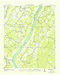 1935 Soddy Island1935 Print · USGSHamilton County communities along the Tennessee River are shown here in the mid-1930s just as TVA development began. Researchers can trace rural life through landmarks like Mt Tabor Community, Bakewell Sch, and the Bald Hill Cem near the riverbanks.
 - 1939 Map of Soddy Island
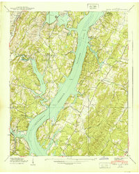 1939 Soddy Island1939 Print · USGSAs the Tennessee Valley Authority reshaped the landscape in the late thirties, this area was caught between its rural past and a new era of hydroelectric power. Trace family roots and submerged landmarks through Bakewell, Thatcher Cem, and the winding Birchwood Pike.4 unique versions available
End of results
Showing maps 1-2 of 2
Top cities near Shady Acres
- Chattanooga historical maps
- Cleveland historical maps
- Soddy-Daisy historical maps
- Dayton historical maps
- Collegedale historical maps
- Walden historical maps
See more
Frequently asked questions
- What are the different types of historical maps available for Shady Acres?
- What is the oldest map of Shady Acres?
- Where can I purchase historical maps of Shady Acres for my home or office?
- Where can I download high-res historical maps of Shady Acres?
- Are there historical topographic maps available for Shady Acres?
- Is there historical aerial imagery available for Shady Acres?
- Where are historical maps of Shady Acres sourced from?