1940s Maps of North Soddy, Soddy-Daisy
Explore 2 historic maps of North Soddy from the 1940s. These maps offer a rare glimpse into what life looked like during the 1940s — showing old roads, neighborhoods, homes, and landmarks that have changed or disappeared over time.
Whether you're researching your family's past, planning a metal detecting trip, or studying how North Soddy's landscape evolved across the 1940s, these high-resolution maps are a powerful tool for exploring the history of this region.
- Focus on a specific era: All maps on this page are from the 1940s, giving you a focused view of this time period.
- See what’s changed: Compare century-old streets, trails, and buildings to today's modern landscape using overlays and satellite layers.
- Research with precision: Use these maps for genealogy, historical research, land use analysis, or educational projects.
- View, download, or print: Maps are fully viewable online in high resolution, and can be downloaded or printed for your own records.
Start exploring North Soddy's history through authentic maps from the 1940s. This is your window into the past.
North Soddy, Soddy-Daisy maps
(2)- 1946 Map of Soddy, 1960 Print
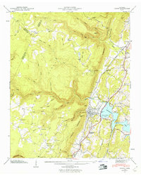 1946 Soddy1960 Print · USGSHamilton County settlement meets the newly formed Chickamauga Lake shoreline in the years following the second World War. Genealogists can trace family roots through the Soddy-Daisy High School and numerous burial grounds like Lovelady Cem and Millsaps Cem.2 unique versions available
 - 1947 Map of Soddy
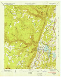 1947 Soddy1947 Print · USGSSoddy and the Tennessee Valley landscape are captured here in the late 1940s as the new reservoir and traditional industry met. Genealogists can trace family roots through the Soddy Cem, Mowbray Sch, and old rail stops like Rathburn Station.
End of results
Showing maps 1-2 of 2
Top cities near North Soddy
- Chattanooga historical maps
- Cleveland historical maps
- Soddy-Daisy historical maps
- Dayton historical maps
- Collegedale historical maps
- Signal Mountain historical maps
See more
Frequently asked questions
- What are the different types of historical maps available for North Soddy?
- What is the oldest map of North Soddy?
- Where can I purchase historical maps of North Soddy for my home or office?
- Where can I download high-res historical maps of North Soddy?
- Are there historical topographic maps available for North Soddy?
- Is there historical aerial imagery available for North Soddy?
- Where are historical maps of North Soddy sourced from?