1930s Maps of Martin Creek, Tennessee
Explore 2 historic maps of Martin Creek from the 1930s. These maps offer a rare glimpse into what life looked like during the 1930s — showing old roads, neighborhoods, homes, and landmarks that have changed or disappeared over time.
Whether you're researching your family's past, planning a metal detecting trip, or studying how Martin Creek's landscape evolved across the 1930s, these high-resolution maps are a powerful tool for exploring the history of this region.
- Focus on a specific era: All maps on this page are from the 1930s, giving you a focused view of this time period.
- See what’s changed: Compare century-old streets, trails, and buildings to today's modern landscape using overlays and satellite layers.
- Research with precision: Use these maps for genealogy, historical research, land use analysis, or educational projects.
- View, download, or print: Maps are fully viewable online in high resolution, and can be downloaded or printed for your own records.
Start exploring Martin Creek's history through authentic maps from the 1930s. This is your window into the past.
Martin Creek, TN maps
(2)- 1932 Map of Hagan
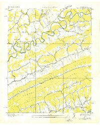
 1932 Hagan1932 Print · USGSThe rugged borderlands of Kentucky and Virginia come to life in this early 1930s survey of the high gaps and hollows. Researchers can locate remote mountain landmarks like Hensley Sch, Feepee Store, and the scattered cabins at Alva.3 unique versions available
 - 1935 Map of Back Valley
 1935 Back Valley1935 Print · USGSThe Tennessee-Virginia borderlands in the mid-1930s reveal a landscape of river-bend settlements and mountain gaps. Genealogists can trace early homesteads and community centers like Wolfenbarger Ch, Mulberry Gap, and Sand Springs Sch along the river valleys.
End of results
Showing maps 1-2 of 2
Top cities near Martin Creek
- Bean Station historical maps
- New Tazewell historical maps
- Tazewell historical maps
- Sneedville historical maps
- Jonesville historical maps
- Rose Hill historical maps
See more
Frequently asked questions
- What are the different types of historical maps available for Martin Creek?
- What is the oldest map of Martin Creek?
- Where can I purchase historical maps of Martin Creek for my home or office?
- Where can I download high-res historical maps of Martin Creek?
- Are there historical topographic maps available for Martin Creek?
- Is there historical aerial imagery available for Martin Creek?
- Where are historical maps of Martin Creek sourced from?