1900s (20th Century) Maps of Bruton Branch, Tennessee
Explore 7 historic maps of Bruton Branch from the 1900s (20th Century). These maps offer a rare glimpse into what life looked like during the 1900s — showing old roads, neighborhoods, homes, and landmarks that have changed or disappeared over time.
Whether you're researching your family's past, planning a metal detecting trip, or studying how Bruton Branch's landscape evolved across the 1900s, these high-resolution maps are a powerful tool for exploring the history of this region.
- Focus on a specific era: All maps on this page are from the 1900s, giving you a focused view of this time period.
- See what’s changed: Compare century-old streets, trails, and buildings to today's modern landscape using overlays and satellite layers.
- Research with precision: Use these maps for genealogy, historical research, land use analysis, or educational projects.
- View, download, or print: Maps are fully viewable online in high resolution, and can be downloaded or printed for your own records.
Start exploring Bruton Branch's history through authentic maps from the 1900s. This is your window into the past.
Bruton Branch, TN maps
(7)- 1936 Map of Pickwick
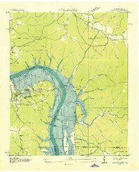 1936 Pickwick1936 Print · USGSThe Tennessee-Alabama border country stands at the brink of change during the New Deal era as the valley prepares for inundation. Genealogists can locate family landmarks like Shanghai Ch, the CCC Camp, and numerous schools including Walnut Grove Sch.
 - 1949 Map of Pickwick, 1967 Print
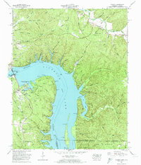
 1949 Pickwick1967 Print · USGSThe Tennessee and Alabama borderlands were being reshaped by hydroelectric power in the late 1940s. Researchers can trace family history through local landmarks like Shanghai Ch, Bryson Sch, and the Old White Sulphur Springs Cem.
 - 1952 Map of Pickwick
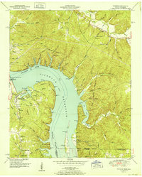 1952 Pickwick1952 Print · USGSThe Tennessee River valley at mid-century reveals a landscape transformed by the Pickwick Landing Dam and the rising Pickwick Reservoir. Genealogists can locate rural landmarks like Shanghai Ch, Bryson Sch, and the Old White Sulphur Springs Cem.
 - 1956 Map of Blytheville, 1964 Print
 1956 Blytheville1964 Print · USGSWest Tennessee and the Arkansas Delta come alive in this mid-century survey of the river-and-rail corridor connecting Memphis to Jackson. Genealogists and historians can trace the rail lines of the Louisville and Nashville RR and locate landmarks like Western State Hospital or Fort Pillow State Prison Farm.2 unique versions available
 - 1959 Map of Blytheville
 1959 Blytheville1959 Print · USGSWest Tennessee and Northeast Arkansas meet along the river in the late fifties, during a period of steady industrial and agricultural growth. Genealogists can trace the rail corridors of the Illinois Central through Jackson or explore landmarks like Shiloh National Military Park and Fort Pillow State Prison.
 - 1972 Map of Pickwick, 1974 Print
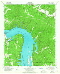
 1972 Pickwick1974 Print · USGSHardin County's river landscape is shown here in the early 1970s, shortly after the Tennessee Valley Authority updated its surveys of the area. Researchers can trace the development of Pickwick Landing State Park or locate historic burial grounds like White Sulphur Cem and Garrett Cem.2 unique versions available
 - 1986 Map of Selmer
 1986 Selmer1986 Print · USGSThe Tennessee River valley and the West Tennessee highlands come into focus in the mid-eighties, showing the region's unique intersection of Civil War history and modern infrastructure. Genealogists and researchers can trace family landmarks like Gillisses Mills, the campus of Freed-Hardeman College, and the hallowed grounds of Shiloh National Military Park.3 unique versions available
End of results
Showing maps 1-7 of 7
Top cities near Bruton Branch
- Savannah historical maps
- Adamsville historical maps
- Crump historical maps
- Burnsville historical maps
- Michie historical maps
- Stantonville historical maps
See more
Frequently asked questions
- What are the different types of historical maps available for Bruton Branch?
- What is the oldest map of Bruton Branch?
- Where can I purchase historical maps of Bruton Branch for my home or office?
- Where can I download high-res historical maps of Bruton Branch?
- Are there historical topographic maps available for Bruton Branch?
- Is there historical aerial imagery available for Bruton Branch?
- Where are historical maps of Bruton Branch sourced from?