1940s Maps of Chilhowee Park, Knoxville
Explore 2 historic maps of Chilhowee Park from the 1940s. These maps offer a rare glimpse into what life looked like during the 1940s — showing old roads, neighborhoods, homes, and landmarks that have changed or disappeared over time.
Whether you're researching your family's past, planning a metal detecting trip, or studying how Chilhowee Park's landscape evolved across the 1940s, these high-resolution maps are a powerful tool for exploring the history of this region.
- Focus on a specific era: All maps on this page are from the 1940s, giving you a focused view of this time period.
- See what’s changed: Compare century-old streets, trails, and buildings to today's modern landscape using overlays and satellite layers.
- Research with precision: Use these maps for genealogy, historical research, land use analysis, or educational projects.
- View, download, or print: Maps are fully viewable online in high resolution, and can be downloaded or printed for your own records.
Start exploring Chilhowee Park's history through authentic maps from the 1940s. This is your window into the past.
Chilhowee Park, Knoxville maps
(2)- 1941 Map of Fountain City
 1941 Fountain City1941 Print · USGSKnox County is captured here just before the mid-century, showing the suburban expansion of Fountain City against the backdrop of the ridge-and-valley landscape. Researchers can locate family landmarks like Lynnhurst Cem, Fort Sumter Sch, and the Beverly Hills Sanitarium.
 - 1942 Map of Knoxville
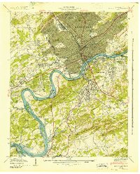 1942 Knoxville1942 Print · USGSKnoxville and its riverfront neighborhoods are shown here at the start of the 1940s, just as the reservoir system began to reshape the valley. Genealogists can trace family roots through numerous burial grounds like Old Gray Cem and Wells Cem, or locate landmarks such as the University of Tennessee.
End of results
Showing maps 1-2 of 2
Frequently asked questions
- What are the different types of historical maps available for Chilhowee Park?
- What is the oldest map of Chilhowee Park?
- Where can I purchase historical maps of Chilhowee Park for my home or office?
- Where can I download high-res historical maps of Chilhowee Park?
- Are there historical topographic maps available for Chilhowee Park?
- Is there historical aerial imagery available for Chilhowee Park?
- Where are historical maps of Chilhowee Park sourced from?