1970s Maps of Chilhowee Park, Knoxville
Explore 2 historic maps of Chilhowee Park from the 1970s. These maps offer a rare glimpse into what life looked like during the 1970s — showing old roads, neighborhoods, homes, and landmarks that have changed or disappeared over time.
Whether you're researching your family's past, planning a metal detecting trip, or studying how Chilhowee Park's landscape evolved across the 1970s, these high-resolution maps are a powerful tool for exploring the history of this region.
- Focus on a specific era: All maps on this page are from the 1970s, giving you a focused view of this time period.
- See what’s changed: Compare century-old streets, trails, and buildings to today's modern landscape using overlays and satellite layers.
- Research with precision: Use these maps for genealogy, historical research, land use analysis, or educational projects.
- View, download, or print: Maps are fully viewable online in high resolution, and can be downloaded or printed for your own records.
Start exploring Chilhowee Park's history through authentic maps from the 1970s. This is your window into the past.
Chilhowee Park, Knoxville maps
(2)- 1978 Map of Knoxville, 1979 Print
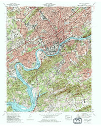 1978 Knoxville1979 Print · USGSKnoxville and its surrounding Knox County suburbs are captured here in the late seventies as the modern interstate system matured. Researchers can trace family roots through numerous city landmarks, from the Old Gray Cem to historic schools and the Southern Railway network.2 unique versions available
 - 1978 Map of Fountain City, 1979 Print
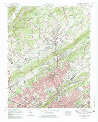 1978 Fountain City1979 Print · USGSNorthern Knox County in the late seventies reveals the steady growth of Fountain City and Inskip along the parallel ridges north of Knoxville. Genealogists can trace family connections through numerous local sites like Lynnhurst Cem, Sterchi Sch, and New Beverly Church.2 unique versions available
End of results
Showing maps 1-2 of 2
Frequently asked questions
- What are the different types of historical maps available for Chilhowee Park?
- What is the oldest map of Chilhowee Park?
- Where can I purchase historical maps of Chilhowee Park for my home or office?
- Where can I download high-res historical maps of Chilhowee Park?
- Are there historical topographic maps available for Chilhowee Park?
- Is there historical aerial imagery available for Chilhowee Park?
- Where are historical maps of Chilhowee Park sourced from?