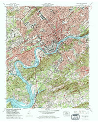
1978 Map of Knoxville
USGS Topo · Published 1979About this map
Knoxville dominates this late-1970s landscape, centered on the bend of the Tennessee River where Fort Loudoun Lake begins. The map details a city in a period of significant infrastructure, showing the complex web of Interstate 40 and Interstate 75 cutting through established neighborhoods like Lonsdale and Lincoln Park. Local history is preserved in the detailed mapping of the University of Tennessee campus and Neyland Stadium, while industrial heritage is evident at the Southern Railway Coster Yards and the Southern Station. To the south, the terrain becomes more varied as it rises toward Bays Mountain, dotted with established residential areas such as Sequoyah Hills and Island Home, the latter adjacent to the Dickinson Island airport. The map serves as a vital record of the city's mid-century expansion and its enduring reliance on the river and rail corridors.
Find a feature on this map
96 named features on this map. Tap any name to fly to it.
Don’t see what you’re looking for? This feature index may not catch every label — zoom into the map to look around manually.
Map Details
Editions of this 1978 Knoxville Map
2 editions found
Other maps of this area

1886 · Knoxville
USGS Topo · 1:125,000

1892 · Knoxville
USGS Topo · 1:125,000

1893 · Briceville
USGS Topo · 1:125,000

1894 · Knoxville
USGS Topo · 1:125,000

1895 · Loudon
USGS Topo · 1:125,000

1895 · Briceville
USGS Topo · 1:125,000

1895 · Knoxville
USGS Topo · 1:125,000

1896 · Briceville
USGS Topo · 1:125,000

1897 · Maynardville
USGS Topo · 1:125,000

1900 · Maynardville
USGS Topo · 1:125,000