
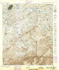
1895 Map of Knoxville
USGS Topo · Published 1895About this map
Knoxville and the winding Tennessee River anchor this late-nineteenth-century survey of the terrain leading toward the high peaks of the Smoky Mountains. The landscape is defined by the confluence of the French Broad River and the Little River, where early transport depended on crossings like Boyd Ferry and Ramsey Ferry. Beyond the growing urban center of Knoxville, the map details a rural network of crossroads and springs, including Cates X Roads and the resort-minded Montvale Springs.
Find a feature on this map
113 named features on this map. Tap any name to fly to it.
Don’t see what you’re looking for? This feature index may not catch every label — zoom into the map to look around manually.
Map Details
Editions of this 1895 Knoxville Map
2 editions found
Other maps of this area

1883 · Morristown
USGS Topo · 1:125,000

1886 · Knoxville
USGS Topo · 1:125,000

1891 · Cowee
USGS Topo · 1:125,000

1892 · Knoxville
USGS Topo · 1:125,000

1893 · Mt Guyot
USGS Topo · 1:125,000

1893 · Morristown
USGS Topo · 1:125,000

1893 · Murphy
USGS Topo · 1:125,000

1893 · Briceville
USGS Topo · 1:125,000

1894 · Knoxville
USGS Topo · 1:125,000

1895 · Morristown
USGS Topo · 1:125,000