Old Maps of Etowah, Tennessee
Explore 28 old maps of Etowah, spanning from 1886 to today. These high-resolution historic maps reveal how streets, neighborhoods, landmarks, and natural features evolved over time — perfect for genealogy, metal detecting, research, and local history exploration.
What you can do with these maps:
- See how Etowah changed over time: Compare historical maps to modern-day views to trace roads, homesites, rail lines & more.
- View detailed metadata: Each map includes creators, publishers, year, scale, and archive source.
- Overlay maps with satellite & LiDAR: Visualize the past alongside modern tools to explore terrain & human change.
- Trusted historical sources: Maps sourced from the USGS, Library of Congress, and other archives.
- Access maps your way: View online, download high-res files, or order prints for personal or research use.
Start exploring old maps of Etowah to uncover forgotten places, hidden landmarks, and the deep history beneath your feet.
Etowah, TN maps
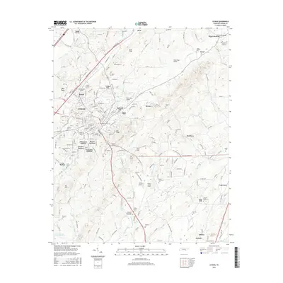
(28)- 1886 Map of Cleveland
 1886 Cleveland1886 Print · USGSSoutheast Tennessee in the mid-1880s was a landscape defined by the iron rails and winding rivers that fueled the region's growth. You can trace early river crossings like Savannah Ford and Kincannons Ferry or locate old community centers like Chestua Mills.
 - 1892 Map of Cleveland
 1892 Cleveland1892 Print · USGSSoutheast Tennessee is captured in the late nineteenth century as a landscape of river ferries and emerging rail junctions. Genealogists and historians can locate early settlements like Charleston and Riceville or trace the original river crossings at Kincannons Ferry and Helderbrand Ford.
 - 1895 Map of Cleveland
 1895 Cleveland1895 Print · USGSSoutheast Tennessee thrived along the Hiwassee River and its rail corridors during the 1890s. Genealogists and historians can trace defunct river crossings like Bunker Hill Ferry and milling sites including Chestuee Mills and Longs Mills.
 - 1901 Map of Cleveland
 1901 Cleveland1901 Print · USGSSoutheast Tennessee was a thriving hub of river and rail commerce at the dawn of the twentieth century. Genealogists can trace family homesteads near vanished landmarks like Marble Switch, Bunker Hill Ferry, or the early settlements of Riceville and Benton.4 unique versions available
 - 1935 Map of Athens
 1935 Athens1935 Print · USGSMid-1930s McMinn County reveals a landscape where traditional crossroads and the emerging power grid meet. Trace family roots through local landmarks like Cedar Springs Cem, Simons Chapel, and the historic railroad junction at Athens.
 - 1935 Map of Etowah
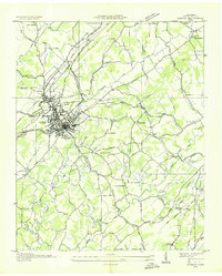
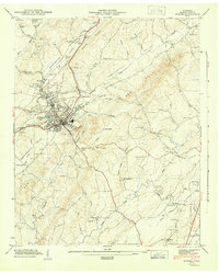
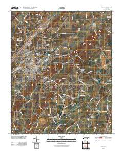
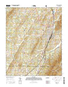
 1935 Etowah1935 Print · USGSThe railroad town of Etowah and its Tennessee Valley surroundings are captured here in the mid-1930s as the rail and quarry industries shaped the landscape. Genealogists can trace family footprints at Gravel Hill Ch's, Longs Mill, and the rail stops at Cambria Station or Delano Sta.
 - 1943 Map of Etowah, 1960 Print
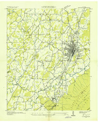
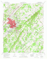
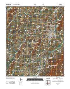
 1943 Etowah1960 Print · USGSMcMinn County in the early 1940s centers on the bustling rail hub of Etowah as it expands along the Louisville and Nashville line. Genealogists and historians can trace family locations at rural landmarks like Old Salem Ch, Gravel Hill Sch, and the Buttram Cem.2 unique versions available
 - 1944 Map of Etowah, 1946 Print
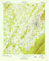
 1944 Etowah1946 Print · USGSMcMinn County in the mid-1940s reveals a landscape defined by the Louisville and Nashville railroad and rural life. Researchers can trace family roots at Buttram Cem or locate vanished schools like Wesleyana Sch.
 - 1944 Map of Athens, 1946 Print
 1944 Athens1946 Print · USGSMcMinn County at the end of the Second World War shows a landscape defined by its rail junctions and ridge-and-valley farming. Genealogists can trace family names through dozens of landmarks, including Cunningham Cem, Zion Hill Sch, and the County Farm.3 unique versions available
 - 1953 Map of Chattanooga
 1953 Chattanooga1953 Print · USGSSoutheast Tennessee in the early fifties shows a landscape reshaped by river management and rail power. Trace the rail lines of the Southern Ry through riverside towns or locate the preserved grounds of the Chickamauga and Chattanooga National Military Park.
 - 1957 Map of Chattanooga, 1966 Print
 1957 Chattanooga1966 Print · USGSEast Tennessee in the mid-1960s shows a landscape of massive hydroelectric reservoirs and emerging industrial sites like the Atomic Energy Commission (Oak Ridge Area). Trace the rail networks of the Southern Ry through Chattanooga or locate family-named ridges across the Cumberland Plateau.3 unique versions available
 - 1959 Map of Chattanooga
 1959 Chattanooga1959 Print · USGSSoutheast Tennessee is shown here during a decade of industrial growth and hydroelectric development. Trace the regional rail networks of the Southern Ry and find landmark sites like Lookout Mountain, Fall Creek Falls State Park, and Chattanooga.
 - 1960 Map of Chattanooga
 1960 Chattanooga1960 Print · USGSSoutheast Tennessee and the southern Appalachians are shown here at the height of the river-management era. You can trace the valley rail lines and locate Lookout Mountain and the expansive waters of Chickamauga Reservoir.
 - 1964 Map of Chattanooga
 1964 Chattanooga1964 Print · USGSSoutheast Tennessee and the western Carolinas appear in the mid-sixties as a powerhouse of river-driven industry and mountain wilderness. Genealogists and historians can trace rail-town lineages along the Southern Ry or locate family landmarks near Watts Bar Lake and Tellico Plains.
 - 1964 Map of Athens, 1966 Print
 1964 Athens1966 Print · USGSAthens in the mid-sixties shows a classic Tennessee rail town evolving into a modern regional center. Genealogists and researchers can locate numerous family landmarks like Cedar Grove Cem, Tennessee Wesleyan College, and the old Antioch Church.5 unique versions available
 - 1967 Map of Etowah, 1970 Print
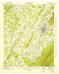
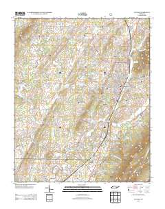
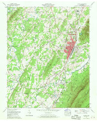 1967 Etowah1970 Print · USGSThe railroad-driven growth of McMinn County is on display in the mid-sixties, from the urban center of Etowah to the Cherokee National Forest. Researchers can trace the Old Federal Road or locate family sites like Delano Mill and Goodsprings Cem.3 unique versions available
 - 1981 Map of Cleveland
 1981 Cleveland1981 Print · USGSSoutheast Tennessee and Western North Carolina are documented here in the early eighties, as the Tennessee Valley Authority managed the region's vast river and forest resources. Researchers can trace the rail lines of the Southern and Louisville and Nashville or locate industrial sites in the Copper Basin and settlements like Ducktown.2 unique versions available
 - 2003 Map of Etowah, 2004 Print
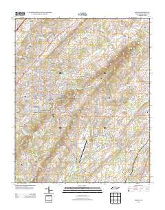
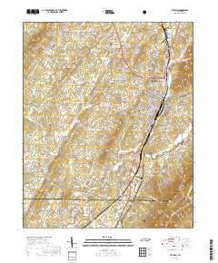
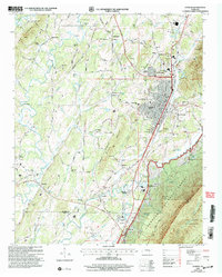 2003 Etowah2004 Print · USGSThe rail-driven hub of Etowah and the rugged slopes of the Cherokee National Forest meet in this detailed survey from the early 2000s. Researchers can trace family roots through sites like Jones Chapel Cem, Old Salem Ch, and the Delano Mill Pond.
 - 2010 Map of Athens, 2010 Print
 2010 Athens2010 Print · USGSCovers Etowah, including Athens, Englewood, and other nearby areas
 - 2011 Map of Etowah, 2011 Print
 2011 Etowah2011 Print · USGSCovers Etowah, including Cambria, Dentville, and other nearby areas
 - 2013 Map of Etowah, 2013 Print
 2013 Etowah2013 Print · USGSCovers Etowah, including Cambria, Dentville, and other nearby areas
 - 2013 Map of Athens, 2013 Print
 2013 Athens2013 Print · USGSCovers Etowah, including Athens, Englewood, and other nearby areas
 - 2016 Map of Athens, 2016 Print
 2016 Athens2016 Print · USGSCovers Etowah, including Athens, Englewood, and other nearby areas
 - 2016 Map of Etowah, 2016 Print
 2016 Etowah2016 Print · USGSCovers Etowah, including Cambria, Dentville, and other nearby areas
 - 2019 Map of Etowah, 2019 Print
 2019 Etowah2019 Print · USGSCovers Etowah, including Cambria, Dentville, and other nearby areas
Showing maps 1-25 of 28
Top cities near Etowah
- Athens historical maps
- Sweetwater historical maps
- Madisonville historical maps
- Englewood historical maps
- Benton historical maps
- Tellico Plains historical maps
See more
Top neighborhoods of Etowah
Frequently asked questions
- What are the different types of historical maps available for Etowah?
- What is the oldest map of Etowah?
- Where can I purchase historical maps of Etowah for my home or office?
- Where can I download high-res historical maps of Etowah?
- Are there historical topographic maps available for Etowah?
- Is there historical aerial imagery available for Etowah?
- Where are historical maps of Etowah sourced from?