1930s Maps of Etowah, Tennessee
Explore 2 historic maps of Etowah from the 1930s. These maps offer a rare glimpse into what life looked like during the 1930s — showing old roads, neighborhoods, homes, and landmarks that have changed or disappeared over time.
Whether you're researching your family's past, planning a metal detecting trip, or studying how Etowah's landscape evolved across the 1930s, these high-resolution maps are a powerful tool for exploring the history of this region.
- Focus on a specific era: All maps on this page are from the 1930s, giving you a focused view of this time period.
- See what’s changed: Compare century-old streets, trails, and buildings to today's modern landscape using overlays and satellite layers.
- Research with precision: Use these maps for genealogy, historical research, land use analysis, or educational projects.
- View, download, or print: Maps are fully viewable online in high resolution, and can be downloaded or printed for your own records.
Start exploring Etowah's history through authentic maps from the 1930s. This is your window into the past.
Etowah, TN maps
(2)- 1935 Map of Athens
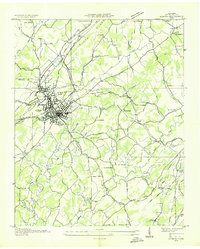 1935 Athens1935 Print · USGSMid-1930s McMinn County reveals a landscape where traditional crossroads and the emerging power grid meet. Trace family roots through local landmarks like Cedar Springs Cem, Simons Chapel, and the historic railroad junction at Athens.
 - 1935 Map of Etowah
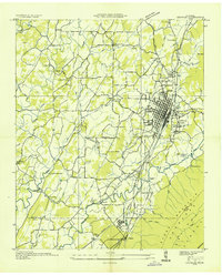 1935 Etowah1935 Print · USGSThe railroad town of Etowah and its Tennessee Valley surroundings are captured here in the mid-1930s as the rail and quarry industries shaped the landscape. Genealogists can trace family footprints at Gravel Hill Ch's, Longs Mill, and the rail stops at Cambria Station or Delano Sta.
End of results
Showing maps 1-2 of 2
Top cities near Etowah
- Athens historical maps
- Sweetwater historical maps
- Madisonville historical maps
- Englewood historical maps
- Benton historical maps
- Tellico Plains historical maps
See more
Top neighborhoods of Etowah
Frequently asked questions
- What are the different types of historical maps available for Etowah?
- What is the oldest map of Etowah?
- Where can I purchase historical maps of Etowah for my home or office?
- Where can I download high-res historical maps of Etowah?
- Are there historical topographic maps available for Etowah?
- Is there historical aerial imagery available for Etowah?
- Where are historical maps of Etowah sourced from?