1930s Maps of Coker Creek, Tennessee
Explore 2 historic maps of Coker Creek from the 1930s. These maps offer a rare glimpse into what life looked like during the 1930s — showing old roads, neighborhoods, homes, and landmarks that have changed or disappeared over time.
Whether you're researching your family's past, planning a metal detecting trip, or studying how Coker Creek's landscape evolved across the 1930s, these high-resolution maps are a powerful tool for exploring the history of this region.
- Focus on a specific era: All maps on this page are from the 1930s, giving you a focused view of this time period.
- See what’s changed: Compare century-old streets, trails, and buildings to today's modern landscape using overlays and satellite layers.
- Research with precision: Use these maps for genealogy, historical research, land use analysis, or educational projects.
- View, download, or print: Maps are fully viewable online in high resolution, and can be downloaded or printed for your own records.
Start exploring Coker Creek's history through authentic maps from the 1930s. This is your window into the past.
Coker Creek, TN maps
(2)- 1934 Map of Tellico Plains
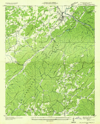 1934 Tellico Plains1934 Print · USGSMonroe County mountain life is captured here in the mid-thirties, showing the rail and river economy of the Tellico River valley. Researchers can trace old mountain schools and family sites like Atkins Sch, Murphys Mill, and Leonards Chapel.
 - 1935 Map of Tellico
 1935 Tellico1935 Print · USGSMonroe County was a landscape of mountain ridges and remote outposts in the mid-1930s, anchored by the rail hub at Tellico Plains. Genealogists and researchers can trace family landmarks like Carpenter Cem, Oldman Mill, and the Rural Vale School.
End of results
Showing maps 1-2 of 2
Top cities near Coker Creek
- Madisonville historical maps
- Englewood historical maps
- Tellico Plains historical maps
- Ducktown historical maps
Frequently asked questions
- What are the different types of historical maps available for Coker Creek?
- What is the oldest map of Coker Creek?
- Where can I purchase historical maps of Coker Creek for my home or office?
- Where can I download high-res historical maps of Coker Creek?
- Are there historical topographic maps available for Coker Creek?
- Is there historical aerial imagery available for Coker Creek?
- Where are historical maps of Coker Creek sourced from?