1990s Maps of Georgetown, Clarksville
Explore 1 historic maps of Georgetown from the 1990s. These maps offer a rare glimpse into what life looked like during the 1990s — showing old roads, neighborhoods, homes, and landmarks that have changed or disappeared over time.
Whether you're researching your family's past, planning a metal detecting trip, or studying how Georgetown's landscape evolved across the 1990s, these high-resolution maps are a powerful tool for exploring the history of this region.
- Focus on a specific era: All maps on this page are from the 1990s, giving you a focused view of this time period.
- See what’s changed: Compare century-old streets, trails, and buildings to today's modern landscape using overlays and satellite layers.
- Research with precision: Use these maps for genealogy, historical research, land use analysis, or educational projects.
- View, download, or print: Maps are fully viewable online in high resolution, and can be downloaded or printed for your own records.
Start exploring Georgetown's history through authentic maps from the 1990s. This is your window into the past.
Georgetown, Clarksville maps
(1)- 1997 Map of Clarksville, 2002 Print
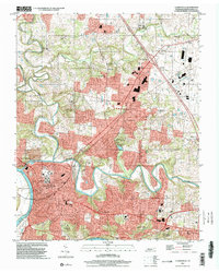 1997 Clarksville2002 Print · USGSThe Clarksville riverfront and its northern suburbs are captured in the late 1990s during a period of steady growth. Trace the expansion of New Providence and St Bethlehem or locate local landmarks like Austin Peay State University and the Dunbar Cave State Natural Area.
End of results
Showing maps 1-1 of 1
Top cities near Georgetown
- Clarksville historical maps
- Hopkinsville historical maps
- Oak Grove historical maps
- Pleasant View historical maps
- Guthrie historical maps
- Adams historical maps
See more
Frequently asked questions
- What are the different types of historical maps available for Georgetown?
- What is the oldest map of Georgetown?
- Where can I purchase historical maps of Georgetown for my home or office?
- Where can I download high-res historical maps of Georgetown?
- Are there historical topographic maps available for Georgetown?
- Is there historical aerial imagery available for Georgetown?
- Where are historical maps of Georgetown sourced from?