1940s Maps of Stowers, Tennessee
Explore 2 historic maps of Stowers from the 1940s. These maps offer a rare glimpse into what life looked like during the 1940s — showing old roads, neighborhoods, homes, and landmarks that have changed or disappeared over time.
Whether you're researching your family's past, planning a metal detecting trip, or studying how Stowers's landscape evolved across the 1940s, these high-resolution maps are a powerful tool for exploring the history of this region.
- Focus on a specific era: All maps on this page are from the 1940s, giving you a focused view of this time period.
- See what’s changed: Compare century-old streets, trails, and buildings to today's modern landscape using overlays and satellite layers.
- Research with precision: Use these maps for genealogy, historical research, land use analysis, or educational projects.
- View, download, or print: Maps are fully viewable online in high resolution, and can be downloaded or printed for your own records.
Start exploring Stowers's history through authentic maps from the 1940s. This is your window into the past.
Stowers, TN maps
(2)- 1943 Map of Twin Bridges, 1965 Print
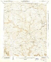
 1943 Twin Bridges1965 Print · USGSMorgan County is captured here in the early 1940s, showing a rural landscape of ridges and river crossings before modern infrastructure. Researchers can trace family history through sites like Deer Lodge Academy, Adkins Mill, and the Shadeland Cem.4 unique versions available
 - 1945 Map of Twin Bridges, 1946 Print
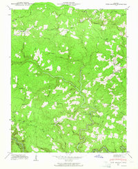
 1945 Twin Bridges1946 Print · USGSThe Cumberland Plateau of Morgan County is captured here in the mid-1940s, showing a landscape of high divides and deep creek hollows. Local historians can trace early community life through Deer Lodge Academy, Adkins Mill, and Island Ford Sch.
End of results
Showing maps 1-2 of 2
Top cities near Stowers
- Crossville historical maps
- Fairfield Glade historical maps
- Jamestown historical maps
- Wartburg historical maps
- Allardt historical maps
- Sunbright historical maps
Frequently asked questions
- What are the different types of historical maps available for Stowers?
- What is the oldest map of Stowers?
- Where can I purchase historical maps of Stowers for my home or office?
- Where can I download high-res historical maps of Stowers?
- Are there historical topographic maps available for Stowers?
- Is there historical aerial imagery available for Stowers?
- Where are historical maps of Stowers sourced from?