1950s Maps of Troy, Tennessee
Explore 5 historic maps of Troy from the 1950s. These maps offer a rare glimpse into what life looked like during the 1950s — showing old roads, neighborhoods, homes, and landmarks that have changed or disappeared over time.
Whether you're researching your family's past, planning a metal detecting trip, or studying how Troy's landscape evolved across the 1950s, these high-resolution maps are a powerful tool for exploring the history of this region.
- Focus on a specific era: All maps on this page are from the 1950s, giving you a focused view of this time period.
- See what’s changed: Compare century-old streets, trails, and buildings to today's modern landscape using overlays and satellite layers.
- Research with precision: Use these maps for genealogy, historical research, land use analysis, or educational projects.
- View, download, or print: Maps are fully viewable online in high resolution, and can be downloaded or printed for your own records.
Start exploring Troy's history through authentic maps from the 1950s. This is your window into the past.
Troy, TN maps
(5)- 1950 Map of Obion
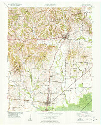 1950 Obion1950 Print · USGSObion County at the midpoint of the century shows a landscape transitioning between traditional river life and modern infrastructure. Genealogists can locate family-named sites such as Beard Cem, Rose Hill Cem, and the community around Englewood Ch.2 unique versions available
 - 1950 Map of Rives, 1970 Print
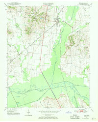 1950 Rives1970 Print · USGSRives and the surrounding Obion County bottomlands are captured here during the mid-century as the region's rail-and-river economy flourished. Genealogists and historians can trace family-named sites like McCutchen Heights, Pleasant Hill Ch, and the intersection of two major railroads at Rives.2 unique versions available
 - 1951 Map of Obion
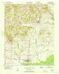 1951 Obion1951 Print · USGSObion County's river-bottoms and upland farms are captured here in the early fifties as the local rail-and-road network matured. Researchers can trace rural lineages through numerous family-named landmarks like Beard Cem, Simpson Cem, and the church at Ebenezer Ch.
 - 1951 Map of Rives
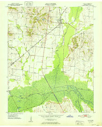 1951 Rives1951 Print · USGSObion County at the start of the 1950s shows a landscape of rail junctions and reclaimed river bottomlands. Researchers can locate family-named settlements like Moffatt and Polk or trace the early church and cemetery locations at Pleasant Hill Ch and Sardis Cem.
 - 1956 Map of Dyersburg, 1960 Print
 1956 Dyersburg1960 Print · USGSThe Four Rivers region comes alive in the mid-fifties, capturing the intricate borderlands of Tennessee, Kentucky, and Missouri. Genealogists and historians can trace the rail-and-river networks connecting Dyersburg, Caruthersville, and the shoreline of Reelfoot Lake.4 unique versions available
End of results
Showing maps 1-5 of 5
Top cities near Troy
- Union City historical maps
- Newbern historical maps
- Hickman historical maps
- Rutherford historical maps
- Obion historical maps
- Hornbeak historical maps
See more
Frequently asked questions
- What are the different types of historical maps available for Troy?
- What is the oldest map of Troy?
- Where can I purchase historical maps of Troy for my home or office?
- Where can I download high-res historical maps of Troy?
- Are there historical topographic maps available for Troy?
- Is there historical aerial imagery available for Troy?
- Where are historical maps of Troy sourced from?