1940s Maps of Copperhill, Tennessee
Explore 5 historic maps of Copperhill from the 1940s. These maps offer a rare glimpse into what life looked like during the 1940s — showing old roads, neighborhoods, homes, and landmarks that have changed or disappeared over time.
Whether you're researching your family's past, planning a metal detecting trip, or studying how Copperhill's landscape evolved across the 1940s, these high-resolution maps are a powerful tool for exploring the history of this region.
- Focus on a specific era: All maps on this page are from the 1940s, giving you a focused view of this time period.
- See what’s changed: Compare century-old streets, trails, and buildings to today's modern landscape using overlays and satellite layers.
- Research with precision: Use these maps for genealogy, historical research, land use analysis, or educational projects.
- View, download, or print: Maps are fully viewable online in high resolution, and can be downloaded or printed for your own records.
Start exploring Copperhill's history through authentic maps from the 1940s. This is your window into the past.
Copperhill, TN maps
(5)- 1941 Map of Mineral Bluff, 1956 Print
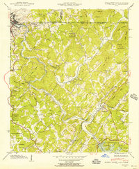 1941 Mineral Bluff1956 Print · USGSThe tri-state borderlands of Georgia, Tennessee, and North Carolina come alive in the early 1940s as the river-and-rail economy hums near Mineral Bluff. Genealogists and researchers can locate the Galloway Cem, trace the Louisville and Nashville Railroad, and find the CCC Camp 3467 TVA 29 site.4 unique versions available
 - 1941 Map of Epworth, 1957 Print
 1941 Epworth1957 Print · USGSThe Tennessee-Georgia state line and the industrial copper basin are captured here in the early 1940s. Genealogists and historians can trace family landmarks like Hipp Chapel, Patterson Mill, and the small settlement of Madola along the Fightingtown Creek.3 unique versions available
 - 1942 Map of Epworth
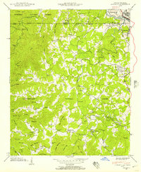
 1942 Epworth1942 Print · USGSThe Georgia-Tennessee border comes alive in the early 1940s, showing the rugged mountain corridor between McCaysville and Epworth. Researchers can trace old mountain homesteads, country schools like Payne Sch, and historic local landmarks such as Higdon Store and Patterson Mill.
 - 1943 Map of Mineral Bluff
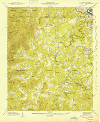
 1943 Mineral Bluff1943 Print · USGSFannin County and the tri-state border region are shown here in the early 1940s, just after the completion of the Blue Ridge Dam. Researchers can trace family history through sites like Galloway Cem or follow the Louisville and Nashville tracks through Mineral Bluff.
 - 1943 Map of Ducktown
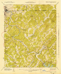
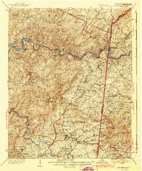 1943 Ducktown1943 Print · USGSSoutheast Tennessee mining country is captured here during the 1940s as the regional copper industry reached its peak. Genealogists and historians can trace industrial footprints at the Burra Burra Mine or locate families near Freelingtown and the Ironsburg Sch.2 unique versions available
End of results
Showing maps 1-5 of 5
Top cities near Copperhill
- McCaysville historical maps
- Blue Ridge historical maps
- Ducktown historical maps
- Morganton historical maps
Top neighborhoods of Copperhill
Frequently asked questions
- What are the different types of historical maps available for Copperhill?
- What is the oldest map of Copperhill?
- Where can I purchase historical maps of Copperhill for my home or office?
- Where can I download high-res historical maps of Copperhill?
- Are there historical topographic maps available for Copperhill?
- Is there historical aerial imagery available for Copperhill?
- Where are historical maps of Copperhill sourced from?