1940s Maps of Putnam County, Tennessee
Explore 6 historic maps of Putnam County from the 1940s. These maps offer a rare glimpse into what life looked like during the 1940s — showing old roads, neighborhoods, homes, and landmarks that have changed or disappeared over time.
Whether you're researching your family's past, planning a metal detecting trip, or studying how Putnam County's landscape evolved across the 1940s, these high-resolution maps are a powerful tool for exploring the history of this region.
- Focus on a specific era: All maps on this page are from the 1940s, giving you a focused view of this time period.
- See what’s changed: Compare century-old streets, trails, and buildings to today's modern landscape using overlays and satellite layers.
- Research with precision: Use these maps for genealogy, historical research, land use analysis, or educational projects.
- View, download, or print: Maps are fully viewable online in high resolution, and can be downloaded or printed for your own records.
Start exploring Putnam County's history through authentic maps from the 1940s. This is your window into the past.
Putnam County, TN maps
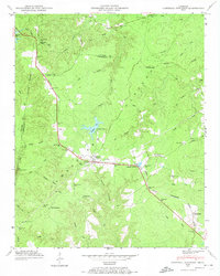
(6)- 1942 Map of Statesville
 1942 Statesville1942 Print · USGSMid-century Tennessee comes alive in this survey of the river valleys and rail lines east of Nashville. Researchers can trace the path of the Tennessee Central Railway and locate historic points like Denny Seminary and Tuckers Crossroads.
 - 1943 Map of Cookeville
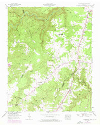
 1943 Cookeville1943 Print · USGSMiddle Tennessee during the early 1940s reveals a landscape defined by the Tennessee Central Railroad and the ascent to the Cumberland Plateau. Trace local heritage through rural settlements like Silver Point and Bloomington Springs or the river crossing at Hodge Ferry.
 - 1944 Map of Cookeville
 1944 Cookeville1944 Print · USGSUpper Tennessee during the war years shows a landscape shaped by deep river gorges and the rising Cumberland Plateau. Researchers can trace old mountain settlements like Bon Air or locate river landmarks such as Hodge Ferry and Burgess Falls Dam.
 - 1946 Map of Campbell Junction, 1974 Print
 1946 Campbell Junction1974 Print · USGSThe high Cumberland Plateau comes into focus in the mid-1940s as the Tennessee Central railroad links small upland communities. Genealogists and local researchers can trace family sites at Welch Cem, Rains Cem, and Pugh Cem or locate the early grounds of Camp Nakanawa.3 unique versions available
 - 1946 Map of Clarkrange, 1976 Print
 1946 Clarkrange1976 Print · USGSThe rural heart of the Tennessee Cumberland Plateau comes into focus in the mid-1940s, centered on the crossroads of Clarkrange. Genealogists and local historians can trace family locations near Union Grove Sch, Muddy Pond, and the Alvin C York Highway.
 - 1946 Map of Obey City, 1976 Print
 1946 Obey City1976 Print · USGSThe Cumberland Plateau of the late 1940s is captured here at a time when coal mining was transforming the rural landscape around Obey City. Researchers can trace old family lineages through Looper Cem and Thompson Cem or follow the Tennessee Central Railroad.2 unique versions available
End of results
Showing maps 1-6 of 6
Top cities of Putnam County
Frequently asked questions
- What are the different types of historical maps available for Putnam County?
- What is the oldest map of Putnam County?
- Where can I purchase historical maps of Putnam County for my home or office?
- Where can I download high-res historical maps of Putnam County?
- Are there historical topographic maps available for Putnam County?
- Is there historical aerial imagery available for Putnam County?
- Where are historical maps of Putnam County sourced from?