1900s (20th Century) Maps of Rhea County, Tennessee
Explore 65 historic maps of Rhea County from the 1900s (20th Century). These maps offer a rare glimpse into what life looked like during the 1900s — showing old roads, neighborhoods, homes, and landmarks that have changed or disappeared over time.
Whether you're researching your family's past, planning a metal detecting trip, or studying how Rhea County's landscape evolved across the 1900s, these high-resolution maps are a powerful tool for exploring the history of this region.
- Focus on a specific era: All maps on this page are from the 1900s, giving you a focused view of this time period.
- See what’s changed: Compare century-old streets, trails, and buildings to today's modern landscape using overlays and satellite layers.
- Research with precision: Use these maps for genealogy, historical research, land use analysis, or educational projects.
- View, download, or print: Maps are fully viewable online in high resolution, and can be downloaded or printed for your own records.
Start exploring Rhea County's history through authentic maps from the 1900s. This is your window into the past.
Rhea County, TN maps
(65)- 1901 Map of Cleveland
 1901 Cleveland1901 Print · USGSSoutheast Tennessee was a thriving hub of river and rail commerce at the dawn of the twentieth century. Genealogists can trace family homesteads near vanished landmarks like Marble Switch, Bunker Hill Ferry, or the early settlements of Riceville and Benton.4 unique versions available
 - 1909 Map of Sequatchie Valley, 1955 Print
 1909 Sequatchie Valley1955 Print · USGSBledsoe County at the turn of the century shows a landscape of river-valley agriculture and rugged plateau crossings. Genealogists can locate family homesteads near landmarks like Mansfield Mill, Smyrna Church, or the Melvine Post Office.
 - 1910 Map of Pikeville
 1910 Pikeville1910 Print · USGSBledsoe County at the turn of the century shows a landscape of valley farms and mountain gaps connected by the Nashville Chattanooga and St Louis RR. Researchers can locate early milling sites like Hembree Mill and rural landmarks such as Melvine PO and Saratoga Springs.2 unique versions available
 - 1935 Map of Rockwood
 1935 Rockwood1935 Print · USGSMid-century Roane County comes into focus as a rail and river crossroads before the landscape was altered by large-scale TVA projects. Genealogists can trace family connections through numerous landmarks like Oak Grove Cem, Eureka, and the Winten Sch.
 - 1935 Map of Melvine
 1935 Melvine1935 Print · USGSBledsoe County’s rural mountain life is preserved here in the mid-1930s, as the valley floor and plateaus were still defined by family-named hollows and gaps. Researchers can locate remote community landmarks like Sunny Meadow Sch, the Lida Thurman Cem, and the village of Melvine.
 - 1935 Map of Morgan Springs
 1935 Morgan Springs1935 Print · USGSWalden Ridge and the Tennessee valley transition are documented here in the mid-1930s, showing a landscape of small schools and plateau settlements. Researchers can trace the Cumberland Escarpment to find Henderson Mill, Morgan Springs, and the Incline railroad.
 - 1935 Map of Goodfield
 1935 Goodfield1935 Print · USGSMeigs and McMinn Counties are captured here in the mid-1930s as the TVA began transforming the Tennessee River valley. Genealogists can locate community landmarks like Shiloh Sch, Allen Store, and Clear Springs Ch among the ridges.
 - 1935 Map of Evensville
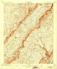
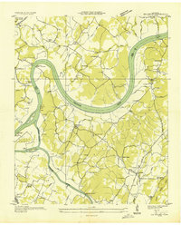
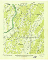
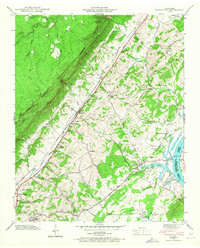
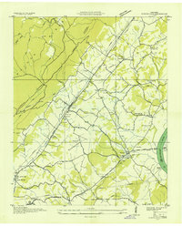 1935 Evensville1935 Print · USGSRhea County is captured in the mid-1930s as the Tennessee Valley Authority begins modernizing the region's infrastructure. Researchers can locate numerous rural landmarks including Henry Ferry, Evens Cem, and old schoolhouses like Locke Sch and Oak Hill Sch.
 - 1935 Map of Decatur
 1935 Decatur1935 Print · USGSThe Tennessee River valley in Meigs County was undergoing significant change in the mid-1930s as the TVA began modernizing the region. Local researchers can trace family roots through numerous river landmarks like Vineyard Landing and rural centers such as Bogles Chapel or Decatur.
 - 1935 Map of Pennine
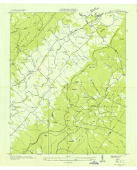
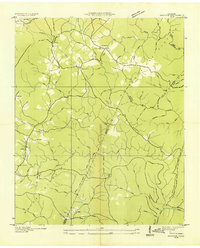
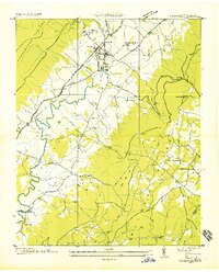
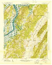
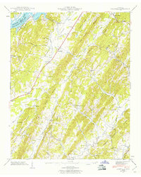
 1935 Pennine1935 Print · USGSRhea County is captured here in the mid-1930s, showing the intersection of ridge-top settlements and valley transport corridors. Genealogists can locate family landmarks such as Milo Post Office, the Rector Mine, and Pleasant Hill Cemetery.
 - 1935 Map of Brayton
 1935 Brayton1935 Print · USGSWalden Ridge was undergoing a rapid transformation in the mid-1930s as new electrical infrastructure reached into the plateau settlements. Researchers can locate the Brayton Sch, Hickory Grove Cem, and long-standing family locations like Hendon and McGill.2 unique versions available
 - 1935 Map of Big Spring
 1935 Big Spring1935 Print · USGSThe Tennessee and Hiwassee rivers define the landscape in the mid-thirties, when ferries were the primary links between Meigs and Rhea counties. Genealogists can trace family roots through labels for Big Spring, Salem Ch, and the Garrison Cem.
 - 1935 Map of Pikeville
 1935 Pikeville1935 Print · USGSBledsoe County is documented here in the mid-1930s as the New Deal began reshaping the Sequatchie Valley. Researchers can trace ancestral locations through Shoemate Cem, locate the CCC Camp Sam Houston No 1466, or follow the Alvin C York Highway.
 - 1935 Map of Graysville
 1935 Graysville1935 Print · USGSRhea and Hamilton counties are shown in detail during the mid-1930s, caught between the ridge-and-valley terrain and the river. Genealogists can locate family landmarks like Welch Cem, trace the historic Blythe Ferry, or find CCC Camp No 3470.
 - 1936 Map of Roddy
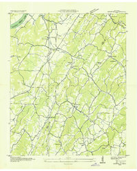
 1936 Roddy1936 Print · USGSThe Tennessee Valley meets the high ridges of the plateau in the 1930s, showing a landscape of small schools, relief camps, and early highways. Genealogists can locate family landmarks such as Gibson Inn, Dogwood School, and Mt Zion Cemetery.
 - 1936 Map of Spring City
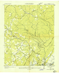
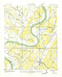
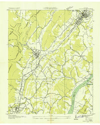
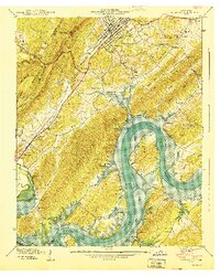
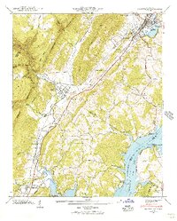
 1936 Spring City1936 Print · USGSRhea County is captured here in the mid-1930s as the Tennessee Valley Authority began modernizing the river valley. Genealogists and historians can trace family locations near Rhea Springs, visit the Pinhook Ferry, or locate rural landmarks like Wolf Creek Ch.
 - 1936 Map of Grassy Cove
 1936 Grassy Cove1936 Print · USGSCumberland County life in the mid-1930s is defined by the unique karst geology of the plateau and its isolated mountain settlements. Researchers can pinpoint rural landmarks like Jewett Ch, the Linary Sch, and the high mountain pass at Key Reed Gap.
 - 1936 Map of Ten Mile
 1936 Ten Mile1936 Print · USGSMeigs County and the surrounding ridges come alive in this mid-1930s survey, showing the valley before the full impact of the TVA. Genealogists can trace family landmarks like Baldwin Cem, Hornsby Chapel, and the old Ten Mile Post Office.
 - 1940 Map of Rockwood
 1940 Rockwood1940 Print · USGSThe Tennessee River valley at Rockwood is shown here during the transition to the reservoir era in the early 1940s. Genealogists can locate family sites like Odd Fellows Cem, trace the railroad to Glen Alice, or find old schools like New Hope Sch.
 - 1940 Map of Spring City
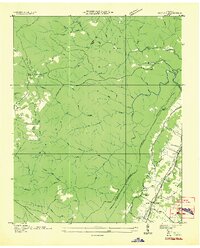
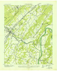
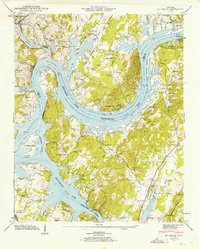
 1940 Spring City1940 Print · USGSRhea County at the start of the 1940s captures a landscape on the brink of transformation as the Watts Bar Reservoir prepared to flood the valley. Genealogists and historians can trace soon-to-be-submerged sites like Rhea Springs and Mc Elwee Landing, or explore the upland reaches of Grandview and Gum Gap.2 unique versions available
 - 1940 Map of Ten Mile
 1940 Ten Mile1940 Print · USGSMeigs and Roane counties are captured here just as the Tennessee Valley Authority was transforming the river landscape. Genealogists and local historians can trace rural family life through markers like Deatherage Cem, Euchee Sch, and the settlement at Ten Mile.
 - 1942 Map of Big Spring
 1942 Big Spring1942 Print · USGSThe Tennessee and Hiwassee Rivers meet in the early 1940s, revealing a landscape of reservoir development and deep-rooted farm communities. Genealogists can locate Big Spring and family sites like Shaver Cem, while historians can trace the Cotton Port Ferry.
 - 1942 Map of Evensville, 1946 Print
 1942 Evensville1946 Print · USGSRhea County is captured here in the early 1940s as the Tennessee Valley Authority projects reshaped the river landscape. Genealogists can trace family names through dozens of landmarks, including Washington Ferry, Smyrna Ch, and the Montgomery Cem.3 unique versions available
 - 1942 Map of Graysville, 1956 Print
 1942 Graysville1956 Print · USGSRhea County and the Tennessee River valley appear here in the early 1940s as newly formed reservoirs altered the landscape. Researchers can trace the historic Blythe Ferry crossing and find long-established local sites like New Providence Sch and the Old Browder Cem.2 unique versions available
 - 1942 Map of Goodfield, 1960 Print
 1942 Goodfield1960 Print · USGSThe Tennessee River valley and its surrounding ridges come alive in this wartime survey of Meigs and Rhea counties. Researchers can pinpoint several family burial grounds like Howser Cem and rural centers including Goodfield and Shiloh Sch.
Showing maps 1-25 of 65
Top cities of Rhea County
Frequently asked questions
- What are the different types of historical maps available for Rhea County?
- What is the oldest map of Rhea County?
- Where can I purchase historical maps of Rhea County for my home or office?
- Where can I download high-res historical maps of Rhea County?
- Are there historical topographic maps available for Rhea County?
- Is there historical aerial imagery available for Rhea County?
- Where are historical maps of Rhea County sourced from?